The History of Cape Henry
by Bob Perrine, Old Donation
Episcopal Church Historian - Dec 2015
You are invited to view “The
First 100 Years In Hampton Roads - the 17th Century” @
http://1bob9.blogspot.com/2009/06/first-100-years.html
The two Light Houses at Cape
Henry -
The Old Cape Henry Light (right) was the 1st lighthouse built by the Federal Government.
The historic lands along Chesapeake Beach stretch eleven miles from the boundary between Norfolk and Virginia Beach to the Atlantic Ocean. Today’s beaches have different names which are (from west to east) Little
Creek, Chic’s, Baylake Pines & Baylake, Aeries on the Bay, Water Oaks, Ocean Park, Point Chesapeake (previously Duck Inn), Cape
Henry, First Landing, and Fort Story. Longtime residents simply call all of
these beaches Chesapeake Beach (many just claim most of Chesapeake Beach to be Chic's Beach). Up the Bay is Norfolk which incorporates (from
west to east) Willoughby Spit, Ocean View and East Beach.
 From the east end of the Joint Expeditionary Base-Little Creek 4.4 miles to the west end of First Landing State Park, the beach is open to the public, curb parking and beach access free of charge; except the 0.4 miles from 4399 Sandy Bay Drive to 4201 Sandy Bay Drive is noted by the above sign as a private beach for only community residents of Baylake Pines and Baylake Beach.

35 Million Years Ago – the Chesapeake Bay Impact Crater. A massive meteor hit in the vicinity of Cape Charles, Virginia, punching a deep crater in the ocean floor. At that time the ocean shoreline extended to Richmond. Millions of tons of water, sediment, and shattered rock were cast high into the atmosphere for hundreds of miles along the East Coast. An enormous seismic tsunami engulfed the land and overtopped the Blue Ridge Mountains, providing the reason sea shells can be found high atop the Blue Ridge.
 Chesapeake Bay Impact Crater Rim Formed a Shallow Bay along Chesapeake
Beaches
Chesapeake Bay Impact Crater Rim Formed a Shallow Bay along Chesapeake
Beaches


Three of these road signs are at entrances to Cape Henry Beach.
Just east of Bayfront Communities is a one mile stretch of First Landing State Park Beach. The entrance is free for bikers, walkers, and bus #35 (Vista Circle near the east side of the Lesner Bridge to the park and down the Ocean Front to Arctic Ave and 19th St); however, a $5 fee ($7 on weekends) is collected at the park entrance for parking. The beach is equipped with restrooms, laundry room, and a City of Virginia Beach maintained visitor's center with very good displays of the April 26th, 1607 Jamestown Settlers' landing at Cape Henry where they stayed for four days exploring before heading up the James River.
35 Million Years Ago – the Chesapeake Bay Impact Crater. A massive meteor hit in the vicinity of Cape Charles, Virginia, punching a deep crater in the ocean floor. At that time the ocean shoreline extended to Richmond. Millions of tons of water, sediment, and shattered rock were cast high into the atmosphere for hundreds of miles along the East Coast. An enormous seismic tsunami engulfed the land and overtopped the Blue Ridge Mountains, providing the reason sea shells can be found high atop the Blue Ridge.

“Chesapeake
Bay Impact Crater”
“The Chesapeake
Bay Bolide (Meteor) Impact: A New View of Coastal Plain Evolution”
http://pubs.usgs.gov/fs/fs49-98
http://pubs.usgs.gov/fs/fs49-98
“Bay Crater
May Extend into Isle of Wight County,” October
24, 2012

“The First Americans,” Jan 2015, National Geographic
18,000 - 400 Years Ago - The First Virginians. Remains of the first Virginians was discovered at an intensely
excavated Pre-Paleoindian site on the Shenandoah River in Warren County (the Pre-Paleoindian period lasted from the Indian arrival until 14,000 years ago) There,
the Pre-Paleoindians quarried jasper from the river’s west bank to make tools.
This area, called the Thunderbird site had a large population due to the vast
number of artifacts discovered contradicting earlier views that Pre-Paleoindian
people lived in small groupings. Another Pre-Paleoindian site was discovered 37 miles north-east
in the Blue Ridge Mountains in Clarke County, Virginia. Concentric stone
circles near rocks weighing more than a ton were placed to mark solar events.
It is possibly the oldest man-made structures in North America still in
existence, twice as old as England’s Stonehenge, and not only with more
features than Stonehenge, its construction shows the advanced civilization at
the time. Artifacts found there, tied it
to the Thunderbird site. At different times in the year the Pre-Paleo-Indians would
visit for ceremonial services.
From the Blue Ridge Mountains the Pre-Paleoindians moved on into the Atlantic coastal region. At that time the Atlantic Ocean was 130 feet lower and 50 miles east of the present Virginia shoreline, and the Chesapeake Bay was still the ancient Susquehanna River. They built villages from North Carolina to Nova Scotia. Called Eastern Woodland Indians, those along the Virginia coast became known as the Chesepian Indians, a name used for the Chesapeake Bay (called "Chesupioc," or “Great Shellfish Bay."). They aligned with the Carolina Algonquian speaking tribes, all living a peaceful existence in separate villages around Currituck Sound and the Chesapeake Bay. Two Chesapeake Indian villages have been found, Apasus and Chesepioc, both near the Lynnhaven River. Archaeologists and others have found numerous Indian artifacts, such as arrowheads, stone axes, pottery and beads at Great Neck Point, and where the first Adam Thoroughgood house was built at today’s Battery Road in Baylake Pines near the shoreline of Lake Joyce on Indian Hill.
The Chesepians lived in peace for many thousands of years until the rise of Chief Powhatan's confederation to the north in the latter sixteenth century, a collection of 30 tribes stretching from modern-day Alexandria to Chesepian tribal land. The Chesepians refused to be part of this confederation, and, as a result, the strongest tribe in Powhatan's confederation, the Nansemond, started whittling away at the Chesepians forcing them to abanded settlements in and around today's Virginia Beach and live in swamp land to the south.
References:
“First Landing State Park and the
Last Trace of a Vanquished Nation,” https://www.abandonedcountry.com/2013/04/01/first-landing-state-park-and-the-last-trace-of-a-vanquished-nation
“Paleo-Indians” - https://en.wikipedia.org/wiki/Paleo-Indians
“Chesapeake People” - http://en.wikipedia.org/wiki/Chesapeake_people
“Paleo-Indians in Virginia” http://www.virginiaplaces.org/nativeamerican/paleoindians.html
"Cactus Hill Archaeological Site on the Nottoway River in Sussex
County"
“Woodland
Indians in Virginia” http://www.virginiaplaces.org/nativeamerican/woodlandindians.html
“Beringia,”
https://en.wikipedia.org/wiki/Beringia
“Powhatan,”
https://en.wikipedia.org/wiki/Powhatan
The Seventeenth Century
1606. Bartholomew Gosnold obtained from King James an exclusive charter for the Virginia Company of London to establish a settlement in the Chesapeake Bay area. On December 20th Gosnold left England with a crew of 144 in three ships.

The story that explains the Jamestown Settlers voyage across the Atlantic to their first four days at Cape Henry and on to Jamestown Island, can be found at the First Landing Beach Visitor's Center, in simple terms for class visits.

Replica of the Susan Constant, largest of the 3 ships, commanded by Captain Christopher Newport

Statue
of Christopher Newport (1561 – 1617) at Christopher Newport University. He was
in command on the initial voyage and in 1609 made several trips back to England for supplies.

Replica of the Godspeed, 2nd largest, commanded by Captain Bartholomew
Gosnold


Stone
cross marking what is believed to be the gravesite of Bartholomew Gosnold (1571
- 1607) at Jamestown Island, Virginia. He was the primary person responsible for
England's colonization the New World.

Replica of the Discovery, smallest of the 3, commanded by Captain John Radcliffe

Sir John James Ratcliffe
(Rattclyffe) (c.1549 - 1609) became the second president of the Jamestown.colony.

Captain John Smith (1580 – 1631)
(Day 1) April 26, 1607 - In the early morning, the Jamestown colonists made landfall at Cape Henry where the Settlers were to open sealed instructions to determine who would be their leader. During the voyage John Smith made many angry and was going to be delt with harshly upon landing. To their surprise the instructions designated John Smith as their leader. He had fought in wars in Europe and was quite different from the men who had never before had dirty hands.
(Day 2) - The next day on April 27 four carpenters assembled a shallop, a boat made in England in portions for storage in the largest ship, the Susan Constant. The shallop could be powered by oars or sails, travel in deep or shallow waters, and was light enough to be pulled ashore. It was about 30 by 8 feet and drew less than 2 feet of water. Like most English boats of the period, the shallop was built of oak planks fastened together with wooden pegs. It had one mast and a sail made of hemp canvas.


(Day 4) - On April 29, before leaving Cape Henry the expedition set up a cross and named the land Cape Henry after Henry Frederick Stuart, Prince of Wales, (1594 – 1612), the elder son of King James I (1566 – 1625).


Cape
Charles, named for Prince Charles I (1600 – 1649), the younger son of King
James I (1566 – 1625).

The
Elizabeth River, named for Elizabeth Stuart (1596 – 1662), the second child and
eldest daughter of King James I (1566 – 1625).

The James River named by Christopher Newport for King
James I (1566 – 1625).

Master George Percy (1580 – 1632)
wrote about the first 4 day events in 1608.
Master George Percy, along with prominent Jamestown leader Captain Gabriel Archer, were known Catholics, a revelation made in 2015 by researchers on Jamestown Island that has caused historians to modify their understanding of that period when the Virginia Company of London proclaimed the Jamestown mission (beside exploring for gold and finding the Northwest Passage) was to spread Protestantism throughout the New World in competition with Spain's spread of Catholicism.
April 29, 1607. Rowing across the James to the channel they found the day before, they were spotted by friendly members of the Pamunkey tribe who invited them to their village Kecoughtan (today’s Hampton) for food and entertainment.
April 29, 1607. Rowing across the James to the channel they found the day before, they were spotted by friendly members of the Pamunkey tribe who invited them to their village Kecoughtan (today’s Hampton) for food and entertainment.

A statue in the First Landing Beach Visitors Center shows Captain Newport exchanging gifts with the Pamunkey Chief on 29 April 1607. .
April 30, 1607. The next day the
settlers again used the shallop rowing ahead of the three ships to find the
best channel as they completed their 15 day 55 mile journey from Cape Henry up
the James River to Jamestown Island on May 14, to become the site of the first permanent English
settlement in the new world.
May 14, 1607 - The story of Pocahontas (1596-1617) dominates the first years of the Jamestown Settlers. John Smith was saved by Pocahontas while being tied down to be killed by her father, Chief Powhatan, a story Smith wrote in later years is not true. Instead of her early life as a twelve-year-old saving John Smith, the true story is none-the-less admirable. For the first couple of years after the Jamestown Settlers arrival on Jamestown Island, Pocahontas helped her father, Chief Powhatan maintain peace with the English Colonists. She brought food to their fort and then provided much anticipated entertainment, performing cartwheels in front of the settlers, a time before ships started bringing women.
Oct 1609, John Smith was severely injured by an accidental gunpowder explosion in his canoe. He sailed to England for treatment and never returned to Virginia.
After Smith left, seven of nine supply ships arrived between Aug and Oct 1609 without the one with most of the supplies, the Sea Venture. Including John Rolfe, the Sea Venture had been forced off course and wrecked in Bermuda. During the ten month stay there John acquired tobacco seedlings grown in Trinidad and Venezuela.
Arriving in Jamestown May 23, 1610 Rolfe and the crew found the colony starving (the 1609–1610 Starving Time). This was the result of poor leadership in dealing with Powhatan.
1614 - With the absence of Smith, settler/Indian hostilities deepened, and, as a result, Captain Samuel Argall kidnapped Pocahontas. John Rolfe knew the only way to save the colony was to make a deal with Argall for the release of Pocahontas, a deal that led to Rolfe gaining knowledge of Indian tobacco curing techniques, a peace between the Indians and the Settlers, and a forced marriage between Rolfe and Pocahontas. There was no love as told by Walt Disney. The marriage between 29 year-old John Rolfe and 18 year-old Pocahontas on 5 April 1614 broke the conflicts and created a climate of peace for several years. 1617 - Not only a piece, but the seeds of economic prosperity were realized when Rolfe made his first profitable export of tobacco to England. John's tobacco was much sweeter and stronger than the hash tasting tobacco the local Indians were smoking. There was no match for the Indian tobacco. His main competition was with the Spainsh who were exporting their tobacco ahead of Rolfe. To help publize his tobacco, in 1617 Rolfe took 21-year-old Pocahontas to England to show the court the "goodwill" between the colonists and Indians plus to draw attention to his tobacco. Pocahontas was paraded around to parties and events as Rolf’s new wife. Although she was in good health, English people of the times shunned this mixed marriage which was possibly the reason Pocahontas fell ill and died as the couple began their trip back home. The tribesmen who accompanied Pocahontas on the trip believed she was poisoned.
1618 - A year after Pocahontas died, her father Powhatan died, and his brother Opechancanough took over. Things again slowly deteriorated. Opechancanough got tribes on both sides of the river to form alliances, uniting them in hatred against the English.
March 22, 1622 - Opechancanough’s forces attacked unexpectedly in the “the Great Uprising” killing roughly a quarter of the 1,200 English settlers. The English sought revenge, sailing up and down the rivers destroying Indian villages and seizing corn. Opechancanough launched another attack a few years later but was beaten back by English soldiers.
This defeat was the beginning of the end of the Powhatan empire and the beginning of prosperity for Jamestown as Rolfe and others were by this time exporting vast quantities of tobacco.
1646 - Governor Berkeley negotiated the first treaty with neighboring tribes. The English population in Tidewater had reached 8,000 replacing the large number of deaths by the regular arrival of ships from England. This while the Powhatan tribes fell below the ever increasing English numbers.
Rolfe not only brought tobacco to Tidewater Virginia but also earth worms that would generate another cash crop - wood. Ships waiting for tobacco, dumped their ballast of stones and soil into the James River. The soil contained earth worms new to North America. The worms competed with decomposing tree leaves turning the dense forests into a more open and dry landscape. The remaining trees grew larger, and with their fine dense wood they become one of the largest exports from Virginia in the 19th century. By the mid-20th century, in excess of 95% of the Old Growth Forests in Virginia Beach were gone.

References:
“Full text of Master George Percy’s Narratives of early Virginia, 1606-1625"
http://archive.org/stream/narrativesofearl1946tyle/narrativesofearl1946tyle_djvu.txt
“A
Skeleton, a Catholic Relic, and a Mystery About American Origins,” Jul 28,
2015
“Bruno: Jamestown's Catholic Connection,” the
Virginian Pilot, July 30, 2015 -
“First Landing at Cape Henry,” 1608 by Master George Percy
“George Percy,” http://en.wikipedia.org/wiki/George_Percy
“Joint Expeditionary Base East (Ft Story)”
http://en.wikipedia.org/wiki/Joint_Expeditionary_Base_East
"Jamestown Supply Missions," Wikidepia - https://en.wikipedia.org/wiki/Jamestown_supply_missions
"John Rolfe," Jamestown Rediscovery - https://historicjamestowne.org/history/pocahontas/john-rolfe
Jamestown: How John Rolfe, Tobacco and Worms Changed the Landscape of America https://www.pennlive.com/americanhistory101/2008/02/jamestown_how_john_rolfe_tobac.html
"Virginia Beach Notable Trees Program," https://www.lynnhavenrivernow.org/notable-trees-program
The Lynnhaven River is shown on the below sketch before 1667 overlaid on a current map. Its mouth to the Chesapeake was at Little Creek. Since there was no outlet where the Lesner Bridge is today, Cape Henry Beach extended from the mouth of the Atlantic to Little Creek.
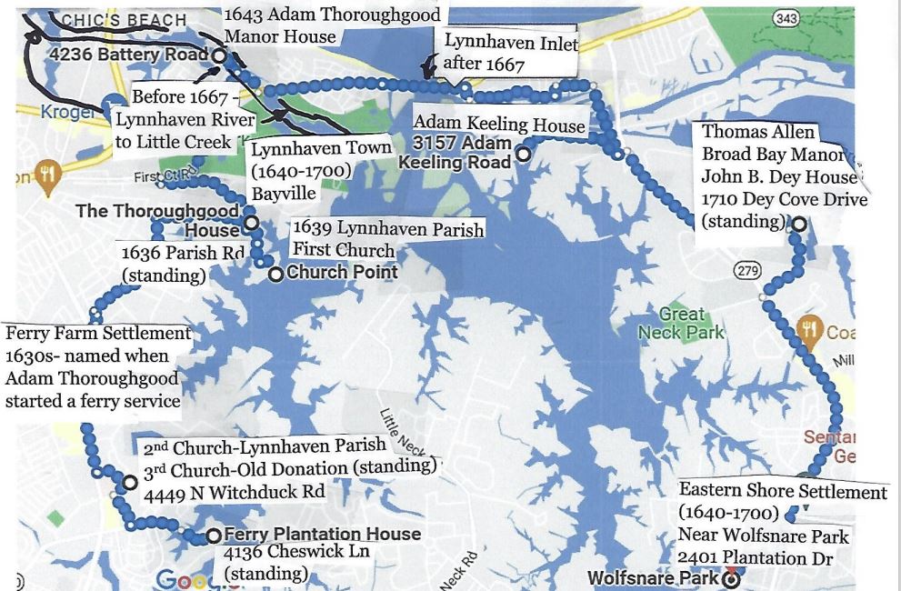
1667 - Re-routing
of the Lynnhaven River. Adam Keeling (1638 - 1683) organized his neighbors to
dig a small pilot channel from the Lynnhaven River through a huge sandbar about
a half-mile long to the Chesapeake Bay so boats would not have to make the long
two mile journey west to the mouth of the river at Little Creek. Ironically, a
month later on September 6, 1667, following on the heels of a nor’easter and
twelve days of rain thereafter, the dreadful hurricane of 1667 struck, a storm
considered one of the most severe hurricanes to ever strike Virginia. Most of
the homes in the area were destroyed. Area
crops, including corn and tobacco, were beat into the ground. Many livestock
drowned in area rivers due to the twelve foot storm surge. The foundation of
the fort at Point Comfort was swept into the river, and a graveyard of the
First Lynnhaven Parish Church tumbled into the Lynnhaven River. This system was
blamed for enlarging the small pilot channel dug the month before to the size
of an inlet and re-routing the Lynnhaven River permanently.
“The Dreadful Hurricane of 1667,” http://www.hurricanescience.org/history/storms/pre1900s/1667
"Virginia Hurricane History" https://www.wpc.ncep.noaa.gov/research/roth/vahur.htm
Hardships. Neighboring the Chesapeake Bay, the Lynnhaven Parish English colonists suffered from many hazards including wolves, nor'easters, droughts, hurricanes, floods, and attacks by French, Spanish and Dutch ships. Then there were the pirates. The pirate Capt. Kidd had his rendezvous on Pleasure House Creek, then part of the Lynnhaven River, and the English pirate Edward Teach (1680 –1718), better known as Blackbeard, buried his treasure in the huge sand banks near Cape Henry, dunes that were bulldozed during WWII so German u-boats would not have a beacon into the Chesapeake Bay. However, some folks claim he hid his treasures on an island in Lake Joyce which used to have an inlet from the Chesapeake Bay. In 1684 the English Government furnished a ketch for the protection of the Virginia coast. Lookouts were established along the shore for all suspicious vessels, and all ships coming to Virginia were provided with cannon and men trained to shoot them.
Hardships. Neighboring the Chesapeake Bay, the Lynnhaven Parish English colonists suffered from many hazards including wolves, nor'easters, droughts, hurricanes, floods, and attacks by French, Spanish and Dutch ships. Then there were the pirates. The pirate Capt. Kidd had his rendezvous on Pleasure House Creek, then part of the Lynnhaven River, and the English pirate Edward Teach (1680 –1718), better known as Blackbeard, buried his treasure in the huge sand banks near Cape Henry, dunes that were bulldozed during WWII so German u-boats would not have a beacon into the Chesapeake Bay. However, some folks claim he hid his treasures on an island in Lake Joyce which used to have an inlet from the Chesapeake Bay. In 1684 the English Government furnished a ketch for the protection of the Virginia coast. Lookouts were established along the shore for all suspicious vessels, and all ships coming to Virginia were provided with cannon and men trained to shoot them.

Edward Teach (1680 –1718), better known as Blackbeard
The Pleasure House. Pleasure House Beach, a strip of
beach from Little Creek Amphibious Base to Baylake Beach, was first named for a
popular ordinary or tavern - “The Pleasure House” built in the 17th century. It
was one of the first places in America where spirits
could be had, a popular place for Blackbeard and his men. While there
Blackbeard had several men stand lookout for ships to pirate. When spotted
they’d dash back to the Pleasure House along a narrow little road, today’s
Lookout Road, a block from and parallel to the Chesapeake Bay. Besides Lookout
Road there is also Black Beard Road that hugs the east side of Lake Joyce. As proprietor in the early nineteenth century
Mr. Nimmo continued the Pleasure House's reputation for gambling and drinking. During the War of
1812 the tavern was occupied on a regular basis by Virginia militia who used
the second floor as an observation post to observe British movements in the
Bay. The British attacked the house at least two times during the war, setting
it on fire and capturing several militiamen.

From “Haunted
Virgina Beach,” by Alpheus J. Chewning, page 16


1976 - the abandoned “Pleasure House” at the
end of Pleasure House Road on the south end of a small lake.
Photo Credit: The New Tidewater Flashback Group in Facebook
The Eighteenth Century
Lynnhaven’s Golden Age. The eighteenth century was the Golden Age in Lynnhaven Parish with prestigious families becoming wealthy on tobacco and other crops. Families such as the Walkes, Keelings, Moseleys, Lands, and Woodhouses would take week-long excursions to Cape Henry Beach having sent servants ahead with tents, furniture and refreshments. The most famous of these trips was made during the courtship between sixteen year old Elizabeth Walke of the Walke Manor House and thirty-two year old George F. McIntosh of Thalia’s Summerville. Their wedding in 1800, dubbed the “Wedding of the Century,” officiated by the famous Rev Anthony Walke, was a most grand affair at the small Lynnhaven Parish Church with days of celebration at the Walke Manner House and Summerville.

1776 - The American Revolutionary War Years
The Revolutionary War would mark the end of the “Golden Age.” Up until the war, Lynnhaven Parish Church served as the “Mother Church” of a rich and aristocratic Princess Anne County exclusively from English ancestry making up almost half the population, with a quarter being slaves and a quarter Native Americans. Although a few people were beginning to steal away to Presbyterian and Baptist churches, the vast majority of Princess Anne County belonged to one church, the Lynnhaven Parish Anglican Church. Before the war most of the Virginian gentry supported the Crown, but as Virginia tobacco planters fell deeper and deeper into debt to British merchants, and as taxes imposed by the King slowly mounted, attitudes began to change. With the costs imposed on the colonists to pay for their defense, particularly the French and Indian War (1754–63), the cash-poor but potentially land-rich gentry began to support the rebel cause for independence. Leading up to and during the Revolutionary War there was heated debate within Lynnhaven Parish Church between those siding with the British as loyalists and those staunch American patriots. Colonel Edward Hack Moseley (1717 - 1783) was loyal to King George III and remained loyal throughout the war. His son Lt Col Edward Hack Moseley Jr (1743 – 1814) stood on the opposite side, but this did not affect their relationship. One member of Lynnhaven Parish Church went further than just talk. Captain Saunders II (1754 - 1834) chose to be a loyalist and joined the Queen's Loyal Virginia Regiment in opposition to his father, Captain Jonathan Saunders I (1726 – 1765) a staunch American patriot. Although he was not in the battle at Yorktown, the congregation assumed he was. His regiment was at Yorktown for the battle against Washington, but he was ordered to Charleston to command the garrison there.

As a military officer in George Washington's army during the Siege of Yorktown, Sep-Oct 1781, Adam Thoroughgood (1755 – 1782), a 7th generation descendant of the first Adam Thoroughgood has been confused with his son Lemuel Thorowgood. The article by Kathleen Bruce “Down on the Lynnhaven” in the Norfolk Ledger-Dispatch 28 April 1924, said that the house of Colonel Adam Thorowgood was commandeered as a British headquarters. His wife Sarah Calvert Thorowgood bravely stood up to the British soldiers when they offered her husband a pardon if he stopped fighting and came home. In the tradition of Thoroughgood wives, she replied with rebellious indignation, "I would rather see him dead!" However, it was Lemuel Thorowgood who married Sarah Calvert and was at the Battle of Yorktown as an officer in George Washington’s army. He became a Captain, then a Major, and finally a Lt. Colonel by the end of the war. As a result of a war-time wound Lemuel died in 1785.
Ref: "The Identity Crisis of the Adam Thoroughgood House," April 2, 2018, by Janet Cummings, Thorowgood World, Exploring 17th Century Roots & Legacies - https://thorowgoodworld.wordpress.com/2018/04/02/the-identity-crisis-of-the-adam-thoroughgood-house
Hampton Roads would become key in war strategy by the British who considering it a choke point between northern and southern American forces.
After the burning of Norfolk by British Royal Navy ships on January 1, 1776 the American Revolutionary War was mostly fought to the south and north of Hampton Roads. By 1780 the British smelled victory after scoring major defeats in both the north and south. After General Lord Cornwallis captured Savannah and Charleston in the summer of 1780, he moved on to Yorktown to provide a protected harbor for the British fleet in the lower Chesapeake Bay. To complete the severing of the norther and southern components of the American Continental Army, Brigadier General Benedict Arnold was dispatched in Jan 1781 with 1,600 men with instructions to destroy army supplies and storage depots. He raided Richmond and cities along the James River, and finally establishing fortifications in Portsmouth. The British, now confident victory was at hand, could rebuild their American dominance outward to the north and south from Hampton Roads. Their assumptions were premature. Cornwallis might have succeeded if it not been for the French, and the grave mistake of not listening to Benedict Arnold's advice. He said garrisoning at Yorktown would be placing his forces against the water with no escape route. After a heated argument, Cornwallis reassigned Arnold north.
The Revolutionary War would mark the end of the “Golden Age.” Up until the war, Lynnhaven Parish Church served as the “Mother Church” of a rich and aristocratic Princess Anne County exclusively from English ancestry making up almost half the population, with a quarter being slaves and a quarter Native Americans. Although a few people were beginning to steal away to Presbyterian and Baptist churches, the vast majority of Princess Anne County belonged to one church, the Lynnhaven Parish Anglican Church. Before the war most of the Virginian gentry supported the Crown, but as Virginia tobacco planters fell deeper and deeper into debt to British merchants, and as taxes imposed by the King slowly mounted, attitudes began to change. With the costs imposed on the colonists to pay for their defense, particularly the French and Indian War (1754–63), the cash-poor but potentially land-rich gentry began to support the rebel cause for independence. Leading up to and during the Revolutionary War there was heated debate within Lynnhaven Parish Church between those siding with the British as loyalists and those staunch American patriots. Colonel Edward Hack Moseley (1717 - 1783) was loyal to King George III and remained loyal throughout the war. His son Lt Col Edward Hack Moseley Jr (1743 – 1814) stood on the opposite side, but this did not affect their relationship. One member of Lynnhaven Parish Church went further than just talk. Captain Saunders II (1754 - 1834) chose to be a loyalist and joined the Queen's Loyal Virginia Regiment in opposition to his father, Captain Jonathan Saunders I (1726 – 1765) a staunch American patriot. Although he was not in the battle at Yorktown, the congregation assumed he was. His regiment was at Yorktown for the battle against Washington, but he was ordered to Charleston to command the garrison there.

Captain John Saunders II (1754 - 1834)
Photo from the American Revolution Museum at Yorktown, Virginia
Ref: "The Identity Crisis of the Adam Thoroughgood House," April 2, 2018, by Janet Cummings, Thorowgood World, Exploring 17th Century Roots & Legacies - https://thorowgoodworld.wordpress.com/2018/04/02/the-identity-crisis-of-the-adam-thoroughgood-house
Hampton Roads would become key in war strategy by the British who considering it a choke point between northern and southern American forces.
After the burning of Norfolk by British Royal Navy ships on January 1, 1776 the American Revolutionary War was mostly fought to the south and north of Hampton Roads. By 1780 the British smelled victory after scoring major defeats in both the north and south. After General Lord Cornwallis captured Savannah and Charleston in the summer of 1780, he moved on to Yorktown to provide a protected harbor for the British fleet in the lower Chesapeake Bay. To complete the severing of the norther and southern components of the American Continental Army, Brigadier General Benedict Arnold was dispatched in Jan 1781 with 1,600 men with instructions to destroy army supplies and storage depots. He raided Richmond and cities along the James River, and finally establishing fortifications in Portsmouth. The British, now confident victory was at hand, could rebuild their American dominance outward to the north and south from Hampton Roads. Their assumptions were premature. Cornwallis might have succeeded if it not been for the French, and the grave mistake of not listening to Benedict Arnold's advice. He said garrisoning at Yorktown would be placing his forces against the water with no escape route. After a heated argument, Cornwallis reassigned Arnold north.

he was credited for his decisive leadership in the
Battle of Saratoga in 1777,
but because he was not promoted he switched sides
to fight for the British in Virginia.
March 16, 1781 -The Battle of Cape Henry. Local residents saw British battle ships anchored at the mouth of the
Lynnhaven River. They had arrived that evening after being mauled by a French fleet
under the command of Admiral Destouches during the Battle of Cape Henry. Destouches
had soundly beaten the English fleet under the Command of Vice Admiral Arbuthnot and could have completely destroy the British
fleet, but instead Destouches sailed to Newport RI, a tactical error, leaving the
Chesapeake under British control and allowing Benedict Arnold’s troops to remain garrisoned in Portsmouth. They would continue raiding up and down the James
River cutting off supplies to American patriots fighting in the Carolina's.
September 5, 1781 - The Battle of the Capes. On September 1, Admiral deGrasse, commander of the
French fleet, arrived near the mouth of the Lynnhaven River in a five day wait
for the British. He detached a few of his ships to blockade the York and James
Rivers farther up the bay. Many of his ships at anchor were missing
officers, men, and boats when the British fleet was sighted on the morning of
September 5, 1781. Their arrival caught de Grasse completely off guard. Local
residents were at the time helping the French gather supplies. DeGrasse had to leave as
many as 200 of his crew behind when he ordered his fleet to cut anchor at 11:30 a.m. to begin
sailing out of the bay with the noon tide. The French took more than four hours
to move single file through the then 1781 Bay's narrow channel. Admiral Graves commander
of the English fleet waited 15 miles from the mouth of the bay, a tragic tactical mistake. About 4:00 pm the French ships cleared
the Bay. The British were the first to open fire, but the French got the first advantage by aiming at British
masts and rigging, crippling the two led British ships. The 2-1/2 hour epic battle ensued just
out of visual sight off Cape Henry, perhaps the most significant battle in
American history. By holding the British fleet from reaching Lord Cornwallis at
Yorktown with vital supplies and assuring General Washington of a victory
over Cornwallis at Yorktown, this sea battle became the critical one in securing America's independence from England.
Some or all of the leaders of Princes Anne County, who had helped deGrasse with supplies, gathered at the point of Cape Henry to see smoke and hear the cannon fire in the distance. Included in the gathering most likely were:
Some or all of the leaders of Princes Anne County, who had helped deGrasse with supplies, gathered at the point of Cape Henry to see smoke and hear the cannon fire in the distance. Included in the gathering most likely were:
*Parents of three patriots who fought in the
War of 1812; twelve year old John Henderson (1769 – 1825), three year old
Anthony Walke (1778-1820) and one year old John Brownley (1780-1853).
*Reverend Anthony Walke III (1755 - 1814)
*William Walke (1762 - 1795)
*Captain Thomas Walke IV (1760-1797)
*Colonel Edward Hack Moseley I (1717 - 1783),
*Colonel Edward H. Moseley Jr. (1743 - 1814)
Sep 5, 1781, the Battle of the Capes (French on the left and British on the right)


"I wish it was in my power to express to Congress how much I feel myself indebted to the Count deGrasse and his fleet." G. Washington Oct 19, 1781.
"I consider myself infinately happyto have been of some service to the United States reserve me a palce in your memory." deGrasse Nov 3, 1781
A memorial stone plaque at Historic Jamestown Colonial National Historic Parks Cape Henry
"I consider myself infinately happyto have been of some service to the United States reserve me a palce in your memory." deGrasse Nov 3, 1781
A memorial stone plaque at Historic Jamestown Colonial National Historic Parks Cape Henry

French Fleet Commander François-Joseph Paul, Marquis de Grasse


A statue of French Fleet Commander François-Joseph Paul, Marquis de Grasse
is at Fort Story (today’s Joint Expeditionary Base East).
The below interpretive sign, Battle of the Capes, September 5, 1781 is located along a Pleasure House Point between the Pleasure House boat dock and Dinwiddie Rd. It was installed in June 2015 as part of the Washington Rochambeau Revolutionary Route National Historic Trail as a joint project of the National Park Service and the Virginia Beach Parks and Recreation Department.


September 18, 1781. The Virginia State Historical Highway Marker, Meeting of Three Commanders, dedicated March 6, 2019, at Lynnhaven Colony Park on Shore Drive, across from Beach Haven Drive, focuses specifically on the September 18, 1781 meeting of Washington, Rochambeau and de Grasse, overlapping content with the above interpretive sign Battle of the Capes, September 5, 1781.

National Archives – Founders Online - Washington Papers - Sep 1781 https://founders.archives.gov/documents/Washington/01-03-02-0007-0005
September 3, 1783. The Revolutionary War put an end to the “Golden Age.” Lynnhaven Parish Church had served as the “Mother Church” of a rich and aristocratic Princess Anne County exclusively from English ancestry making up almost half the population, with a quarter being slaves and a quarter Native Americans. Although a few people were beginning to steal away to Presbyterian and Baptist churches, the vast majority of Princess Anne County still belonged to one church, the Lynnhaven Parish Anglican Church. After the Revolutionary War the Virginian gentry's break in loyalty was tested during the 1783 Treaty of Paris when the subject of paying pre-war debts to English merchants was decided in favor of the English merchants. A key point in the treaty “recognized the lawful contracted debts to be paid to creditors on either side.” Further, the Anglican Church was disestablished in all states where it had previously been a privileged religion, and the Virginian gentry lost their high status in the community without an Anglican Church to collect a tithing tax or to purchase a commission in the army or navy. Anglicans were left without organization and the Virginia legislature and local governments began seizing Anglican property, even though it belonged to the newly established Episcopal Church. Out of 107 Virginia parishes before the war only 42 survived. Lynnhaven Parish Church was one of the surviving churches.
References:
"The Revolutionary War in Virginia" - http://www.virginiaplaces.org/military/revwar.html
"Jamestown Settlement & American Revolution Museum" - http://www.historyisfun.org
"American Revolution
Museum at Yorktown" –
http://www.historyisfun.org/yorktown-victory-center/new-yorktown-museum
“Admiral Comte deGrasse” - https://www.nps.gov/came/admiral-comte-degrasse.htm
http://www.historyisfun.org/yorktown-victory-center/new-yorktown-museum
“Admiral Comte deGrasse” - https://www.nps.gov/came/admiral-comte-degrasse.htm
https://www.nps.gov/york/learn/historyculture/battle-of-the-capes.htm
Note: The American Revolution Museum at Yorktown which opened in March 2017 is not for you if you want to learn about Revolutionary War activities in Hampton Roads. For example, under the portrait of Benedict Arnold, the paragraph ends by just saying that after he switched sides he went on to fight for the British in Virginia. That’s all! And as for Captain Saunders II (1754 - 1834) there is just a portrait of him.
June 25, 1788. When land owners became aware the federal government would be unable to collect enough taxes for a nation on the verge of bankruptcy, and a stronger federal document became necessary. Because of their family status, Anthony Walke and his distant cousin Thomas Walke IV (1760 – 1797) were chosen to represent Princess Anne County at the 1788 Virginia Constitutional Convention. They were both great-grandsons of Colonel Thomas Walke (1642-1694), the first Walke to come to Lynnhaven Parish in 1670. In order for the Constitution to become law two-thirds or 9 of the 13 states had to ratify it. After New Hampshire became the 9th state, even though Virginia had yet to vote, they along with New York were locked in bitter debates. Their failure to ratify would reduce the new union by 2 large, populated, wealthy states, geographically splintering the new nation. Patrick Henry (1736 - 1799) argued for hours at the Virginia convention against the Constitution, but James Madison’s (1751-1836) persuasive and subtle logic persuaded the Walkes, and others in Tidewater to vote for the new constitution, and on June 25, 1788, by a narrow margin, Virginia voted "yes." With Virginia voting yes, New York caved and also by a narrowly vote approved the Constitution.
The Pilot Boats. Harbor pilots first started working in Hampton Roads early in the 18th century. They helped to end the American Revolution in 1781 by guiding the French fleet to the Virginia Capes in time to defeat the British (the Battle of the Capes). During the Civil War, the U.S. frigate Merrimac was escorted by four armed pilot boats to its epic meeting with the Union Navy’s USS Monitor. In 1866 the Virginia Pilot Association was formed and a seventy-two foot wooden schooner was anchored off Cape Henry to serve as the pilot’s base station for maritime traffic entering the Chesapeake Bay, the last in 1983 being the steel steam cutter, pilot boat Virginia III. Pilots would be picked up on the shoreline of Cape Henry and rowed out to the schooner where they would wait for a ship entering the Chesapeake. Then from the schooner sailors would row a pilot to the incoming ship. The pilots job was to guide the ship's captain through the Chesapeake to port.

Virginia III
From “Guardians of the Capes, a History of Pilots and Piloting in Virginia Waters from 1611 to Present”

Virginia III to pick up pilots off the beach at Fort Story.
Picture from “Images of America, Fort Story and Cape Henry,” by Fielding Lewis Tyler, 2005

Capt J.H. Vail is taken ashore at Cape Henry piggyback,
a time-honored custom, by apprentice Ted Wool.
a time-honored custom, by apprentice Ted Wool.
From “Guardians of the Capes, a History of Pilots
and Piloting in Virginia Waters from 1611 to Present”
and Piloting in Virginia Waters from 1611 to Present”

This 1909 painting shows a harbor pilot in a perilous moment
From Virginia Beach in Vintage Postcards by Alpheus J. Chewning, 2004

The George M. Farwell is shown wrecked as it sits grounded October 1906. Just barely visible in the background to the left is the Italian schooner Antonia wrecked and grounded March 1906. Both ships tried to navigate past Cape Henry up the Chesapeake without calling for a a harbor pilot.
From Virginia Beach in Vintage Postcards by Alpheus J. Chewning, 2004
After 1983 two high-speed, 51-foot launches replaced the stationary Virginia III. They were based at the Virginia Pilot Association’s new headquarters just inside the Lynnhaven River. At the same time, a control tower was placed in operation behind the sand dunes close to the Cape Henry Lighthouse, taking over the radar and communications duties formerly conducted on board the Virginia III. Today every ship entering and leaving the Port of Hampton Roads, whether destined for a dock in Norfolk, Portsmouth, Newport News or Baltimore, must have a pilot on board to function as the captain until the ship is either safely docked or safely out into open sea. Almost all harbor pilots make six-figure salaries that can go up to a half-million dollars a year.
After 1983 two high-speed, 51-foot launches replaced the stationary Virginia III. They were based at the Virginia Pilot Association’s new headquarters just inside the Lynnhaven River. At the same time, a control tower was placed in operation behind the sand dunes close to the Cape Henry Lighthouse, taking over the radar and communications duties formerly conducted on board the Virginia III. Today every ship entering and leaving the Port of Hampton Roads, whether destined for a dock in Norfolk, Portsmouth, Newport News or Baltimore, must have a pilot on board to function as the captain until the ship is either safely docked or safely out into open sea. Almost all harbor pilots make six-figure salaries that can go up to a half-million dollars a year.

Above picture shows pilot boats docked at Lynnhaven Inlet.

High powered, very quick and durable, a Pilot Boat is built to withstand heavy seas and bumping against 100,000 ton tanker ships. They are painted a highly visible red.
1789 - The Two Lighthouses

They are located at Cape Henry within the Joint Expeditionary Base East (Ft Story). Congress approved legislation to establish and support lighthouses, beacons, buoys and public piers on Aug. 7, 1789, and being the first lighthouse authorized by the U.S. government, the original Cape Henry Lighthouse was built in 1792 and has long been important for the large amount of ocean-going shipping traffic headed for the harbors within the Chesapeake Bay and its tributaries. Willis A. Hodges, an African American and first lighthouse keeper had to carry drums of whale oil up the slippery steps. Hodges became an influential black leader in Princess Anne County being the county's first black elected representative. During the Civil War, to keep it operational for Union ships, black troops from Fort Monroe were sent to guard it from Confederate attack. The newer, and still standing lighthouse, was completed November 1881, 350 feet away from the first one. Supplies for its construction, were transported on a seven-mile railroad spur built from the Lynnhaven inlet. This spur line would be replaced 21 years later by the Chesapeake Transit Company’s electrified trolley rail line. On January 29, 1964 the old lighthouse was designated a National Historic Landmark open to the public. In 1989, in celebration of the 200th anniversary of the signing of the act and the commissioning of the first federal lighthouse at Cape Henry, Congress designated Aug. 7 as National Lighthouse Day.
Cape Henry Lighthouse - http://www.visitvirginiabeach.com/visitors/articles/cape_henry_lighthouse.aspx
Cape Henry Lighthouse Get Its Day in the Spotlight, Virginian Pilot, Aug 6, 2015 http://hamptonroads.com/2015/08/cape-henry-lighthouse-get-its-day-spotlight
National Lighthouse Day Weekend
The Nineteenth Century
The War of 1812


War of 1812 Marker (front and back)
at Historic Jamestown Colonial National Historic Parks Cape HenryThree American sailors were captured in 1806 and forced into British Royal Navy duty. Escaping from the British they enlisted on the U.S. frigate Chesapeake, but when the Chesapeake cleared Cape Henry June 22, 1807, the British commandeered the ship and recaptured the Americans. This news of yet another violation of American sovereignty along with British attempts to restrict U.S. trade and block American westward expansion led the young nation to declare war against England on June 18, 1812 (war of 1812). Less than a month later on July 8, 1812, just off Cape Henry, on the topsail schooner Dash, members of the Princess Ann County Militia, including Sgt. Brownley, Pvt. Henderson and Pvt. Walke captured the British sloop, HMS Whiting, the first ship captured in the war. All three men are buried in the Old Donation Cemetery. They were honored as patriots by the War of 1812 Society, DAR and SAR on May 17th, 2014.
https://en.wikipedia.org/wiki/HMS_Whiting_(1805)

Not being part of the
American Navy; nonetheless, private armed vessels
such as the Dash were authorized to seize enemy
vessels.
Soon after several initial humiliating
defeats, the British sent a strong naval flotilla that would seize hundreds of
American vessels and raid towns up and down the James River attacking Norfolk
and burning Hampton to the ground. Despite the British strength, the Princess
Ann County Militia continued skirmishes with British landing parties along
Chesapeake beaches throughout the war which lasted until the Treaty of Gent was ratified by the U.S.
Senate on February 18, 1815.
The Twentieth Century
1902-Train Transportation. In 1902 the Chesapeake Transit Company (later merged with the Norfolk and Southern Train Co.) opened an electrified trolley rail line. The line ran east across Lake Smith on a trestle bridge and another across the Lynnhaven River inlet on a rolling lift drawbridge, and on to a railway station at Cape Henry which opened in 1904 and still stands today on the grounds of Fort Story Naval Base. In 1905 the Cape Henry train line connected to the Norfolk and Southern line built north from the ocean front. This created a forty-two-mile electric train loop with train service operating every half hour. In 1926 the open spaces on the surface of the bridge were planted over so that Norfolk and Southern Bus Company could carry passengers to Cape Henry. The electrified trolleys were replaced by gasoline-powered trains in 1935, with services ending at the end of the 1940's with the trestle bridge being torn down. The train station at Fort Story was restored and used at one time as an educational facility by the Navy. Today it is unused, and with talk of restoration, hopefully this historic landmark will be preserved. A state historical marker installed in Sep 2017 near the rail station will certainly help. It describes the past history of the rail lines that ran through the cape.

The dedication of the Cape Henry Railroads Historical Marker was held on Saturday, Aug. 5, 2017.

The N&S electrified trolley #4 on the Cape Henry & VA
Beach line in 1904.
From Virginia Beach in Vintage Postcards by Alpheus J. Chewning, 2004


Old Brick Train Station at Fort
Story with the
two lighthouses in the background (Picture from Dave Burnette)
“Railroads to Cape
Henry in Virginia Beach Get Their Place in History,” by Stacy Parker, The
Virginian-Pilot, Aug 4, 2017https://pilotonline.com/news/local/transportation/railroads-to-cape-henry-in-virginia-beach-get-their-place/article_2ae22ba9-b5f6-5da7-9e8b-bd9efe8721af.html
“Ocean Park
History Project, Virginia Beach,
Virginia Early 1700’s – 1906”
“Brief History of the First Norfolk Southern Railroad”
http://www.norfolksouthernhs.org/briefNShistory.html
"Lighting the
Path to Local History"
"Transportation
in Virginia Beach"
Cape Henry.

Above map from “Twixt Ocean and Pines : the Seaside Resort at Virginia Beach 1880-1930,” page 131 by Jonathan Mark Souther Follow, University of Richmond UR Scholarship Repository Master's Theses Student Research (Note: Fort Story did not include the land around the light houses and O’keefe’s Restaurant and Casino east to the Atlantic until 1941)
William J. O'Keefe began his career as
the proprietor of an ice cream parlor in the basement of the Princess Anne
Hotel. Developing great affection for the cape, he opened the Cape
Henry O'Keefe Casino and Restaurant on July 4, 1903. Soon his
establishment became a success as trains brought customers east from Norfolk
and north from the ocean front.
Passengers
riding the line from the beach front saw few houses en route along the
Atlantic, only sand dunes, swamps, and pine woods. They must have
been startled when the thirty-two-room "Mansion in the Wilderness"
came into view. Built in 1906 by Dr. John Miller Masury, the palatial granite
residence was situated on about 130 acres of land between the ocean and Crystal
Lake. The Masury mansion was complete with ballroom, pipe organ, elevator, and
a half-mile lighted and covered cedar boardwalk that connected to an oceanfront
cottage.


 Oct 8, 1913 - Oyster Roast at O'Keef's Casino and Restaurant
from Sargeant Memorial Collection, Norfolk Slover Library


The Mansion in the Wilderness, 515 Wilder Road, Virginia Beach, Virginia
Dr. John Miller-Masury House, also known as Lakeside (1906–1935), Crystal Club (1935–1939), and Greystone Manor (1942-present), was built in 1906–1908. From 1936 to 1939, it housed the Crystal Club, a gambling casino and nightclub. It was added to the National Register of Historic Places in 1997. https://en.wikipedia.org/wiki/Dr._John_Miller-Masury_House
Over the next decade only two other houses were built on the
beach front, but at the cape resort there was much to see around O'Keefe's Casino and Restaurant. O'Keefe built
bathhouses, a soda fountain and ice cream parlor, refreshment stands, and a
dancing pavilion made popular by Borjes' Orchestra. Beach goers stayed in
cottages and a hotel.
from Virginia Beach in Vintage Postcards by Alpheus J. Chewning, 2004
1909 - Famous Original Oyster Roast at Cape Henry’s O’keefe’s Restaurant and Casino
from Sargeant Memorial Collection, Norfolk Slover Library

Postcard of O'Keef's Casino and Restaurant, from the Robert J. Gilson Collection, Virginia Beach Public Library
O'Keefe's Casino would become the home of the famous Lynnhaven oysters. With
its long picnic tables that were restocked constantly with oysters, O'Keefe's
became a favorite, especially on New Year's Eve, when a special
dinner-breakfast of oysters and Smithfield ham was served. Beside the casino
other pastimes at Cape Henry included climbing and sliding down the huge sand mountains,
enjoying a picnic atop high points of land jutting out into the bay, and
picking wild huckleberries and blackberries. Cape Henry enjoyed such great
success that the Chesapeake Transit Company built larger facilities and soon
offered twenty-five-cent "moonlight excursions" to the cape every
night. In 1908 the Cape Henry Beach Company was formed to promote the Cape Resort.
Despite the considerable popularity of Cape Henry for daily excursions, it
failed to become a complete resort, and the Cape Henry Beach Company quietly
dissolved. The Cape Henry Syndicate assumed responsibility for the land and
revived lot sales for a time, but in a few years it also failed to make Cape
Henry a sizeable resort.
In 1909 President Taft made the Lynnhaven
Oysters famous after eating at O’Keefe’s Restaurant and Casino. He later had them delivered to the White
House, and by singing their praises Taft gave Lynnhaven Oysters national
attention and paved the way for wholesalers to ship them all over the east
coast. By 1912 Slade, C. M. Barnett
(early 20th century owner of the Ferry Farm Plantation Home) was shipping them
to New York’s Waldorf Astoria Hotel and Grand Central Station.
Taft had
originally come to the area in 1905 as Secretary of War to investigate
fortifying the bay. When Taft became president four years later, the bay
remained unprotected even though Fort Wool at the mouth of the James River had
in 1902 been funded for upgrade, but it did not protect the mouth of the Chesapeake.
A debate ensued over whether to build an
island in the middle of the bay or build a fortification at Cape Henry. The
Taft board recommended constructing an island fortress at a cost of about $2.6
million. To bolster support for the island which had been delayed, President
Taft came to back to the area in 1909 to deliver an address in which he
declared his support for the construction of the island fortification midway
between Cape Henry and Cape Charles. The island plan eventually proved too
costly, and in 1913 the federal government instead purchased land at Cape
Henry.
In 1914 the Virginia General Assembly officially turned over nearly 345 acres of pristine bay and ocean front property to the federal government for a military installation naming it for Gen. John Patton Story, a noted coast artilleryman of his day. His distinguished career lasted 40 years.
 Maj. Gen. John Patten Story, former chief of artillery, died one year before Picture from “Images of America, Fort Story and Cape Henry,” by Fielding Lewis Tyler, 2005
After World War I Fort Story entered a period of post-war inactivity which lasted until the beginning of World War II. Not only did O’Keefe’s Restaurant continue in operation, but the production and distribution of illegal distilled spirits (moonshine) sprang up when prohibition was passed in 1920. Positioned at the mouth of the Chesapeake Bay, the wilds of the Cape Henry "Desert" had long been regarded as a "paradise for moonshiners." During this time, Cape Henry played a considerable role in eluding authorities and getting moonshine to locals and the Middle Atlantic region. Even a decade after prohibition ended in 1933, moonshine was still being produced in places along Shore Drive and shipped across the Chesapeake Bay and up the Eastern Shore to northern cities.
In 1941 the Headquarters of the Harbor Defense Command was moved from Fort Monroe to Fort Story requiring more land. Stretching to the ocean, it consumed the land where the two lighthouses and O’Keefe’s Restaurant were located. About this time O’Keefe’s closed.

In preparations for WWII Fort Story again became active. Interior installations were fortified, and fearing German submarines (U-boats) hundreds of mines were laid at the mouth of the Chesapeake, the largest mining operation on the East Coast. In June 1942, a U-boat came into the Chesapeake during the night dropping mines of its own. Over the next few days, five ships collided with the enemy mines and were sunk or damaged, the first time an enemy came to America’s shores. It would be almost another 60 years before another enemy attacked our homeland (September 11, 2001).
Ref: “Fort Story’s Prime Seems Past, Swallowed by Time and Sea. Until Gunfire Crackles In The Woods,” the Virginian Pilot, Nov 30, 2019 by Joanne Kimberlin http://www.pilotonline.com/military/vp-nw-fz-fort-story-then-now-20191130-si57g5kdrfh5jfew5mnusw5qpu-story.html
In 1944, Fort Story began to transition from a heavily fortified coast artillery garrison to a convalescent hospital for returning veterans. By the time of its closing March 15, 1946, the hospital had accommodated more than 13,472 patients.
1920 - The Order of Cape Henry 1607.
Just east of Fort Story the "Order of Cape Henry 1607" was
founded, and beginning in April 1920 yearly services were held to commemorate
Cape Henry as the birthplace of a Christian English-speaking nation. Celebrated
as the "Pilgrimage to the Cross," the event is the oldest, continuous
historical observance in Hampton Roads.
Documented in books and journals, gubernatorial papers and in the
Congressional Record of the United States, the Order has been named in the
proclamations of numerous Virginia governors and mayors, and has been the
subject of correspondence from several United States presidents.
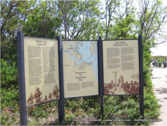
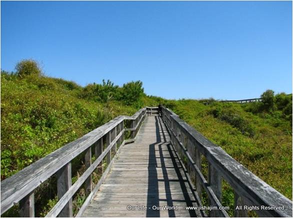
On July 3, 1930 Colonial National Monument was authorized and established. On June 5, 1936, it was re-designated as Historic Jamestown Colonial National Historic Parks operated by the National Park Service including several sites relating to the Jamestown settlers and historical events in the area that include the site of the first landing at Cape Henry, the first English settlement at Jamestown, the Yorktown battlefield, and a scenic 23-mile Colonial Parkway running through the historic district of Colonial Williamsburg linking Jamestown Island and Yorktown. The Cape Henry Memorial Colonial National Historic Park was not incorporated into Fort Story until 1941. The park includes two lighthouses, the granite "Cape Henry Cross," a statute of Admiral deGrasse, a granite memorial to the Battle of the Capes, a three-panel wayside describing Cape Henry's significance to America, the old Fort Story train station, the First Landing Chapel, and a walkway leading to the top of the sand dunes looking out at the Atlantic Ocean and the entrance to the Chesapeake Bay.


April 28, 2019. Pictured above for the First Landing blessing of the "Cape Henry Cross" celebration, Old Donation Episcopal Church (ODEC) is shown which included ODEC Historic Traditions Commission members and Young Historians. Led by the Reverend Robert Randall, ODEC then conducted a service at the First Landing Chapel. This marked the fourth time ODEC has been involved.
Beaches along the Chesapeake Bay become popular.
1919 - Chesapeake Beach known as Chic's Beach
There is a plaque here that reads "Chesapeake Beach, founded 1919." People instead have come to call it Chic's Beach. Luther "Chic" Ledington used to serve up limeade, ice cream, and hot dogs at his little stand.


http://hamptonroads.com/2009/09/whats-name-chics-beach
1918 - Y.W.C.A. Camp Owasia. John B. Dey, for whom Broad Bay Manor / John B. Dey House, Dey Cove Drive and John B. Dey Elementary School were named, had extensive holdings in the area. In 1918 he allowed 25 girls from the Y.W.C.A. camp at Broad Bay Farm to use his property on Cape Henry Beach for camping, crabbing, fishing, and boating. Later in 1922, the Girl’s Work Committee purchased a cottage at Chesapeake Beach and accepted two adjacent lots as gifts from the Norfolk Lot Corp where Water Oaks and Aeries now exist. Named Camp Owasia (a Native American name meaning “camp of happiness”) it operated for nearly 20 years until World War II when the U.S. Army took over the land and used it for training special forces. After the war, the YWCA sold the property and purchased nearby Camp Lynnhaven, originally Camp Robert Hunt, which had been owned by the Episcopal Diocese of Southern Virginia. Unable to pay for the high operating costs the camp closed in 1975, and in 1976 retirement community Westminster Canterbury bought the land.
In 1914 the Virginia General Assembly officially turned over nearly 345 acres of pristine bay and ocean front property to the federal government for a military installation naming it for Gen. John Patton Story, a noted coast artilleryman of his day. His distinguished career lasted 40 years.

After World War I Fort Story entered a period of post-war inactivity which lasted until the beginning of World War II. Not only did O’Keefe’s Restaurant continue in operation, but the production and distribution of illegal distilled spirits (moonshine) sprang up when prohibition was passed in 1920. Positioned at the mouth of the Chesapeake Bay, the wilds of the Cape Henry "Desert" had long been regarded as a "paradise for moonshiners." During this time, Cape Henry played a considerable role in eluding authorities and getting moonshine to locals and the Middle Atlantic region. Even a decade after prohibition ended in 1933, moonshine was still being produced in places along Shore Drive and shipped across the Chesapeake Bay and up the Eastern Shore to northern cities.
In 1941 the Headquarters of the Harbor Defense Command was moved from Fort Monroe to Fort Story requiring more land. Stretching to the ocean, it consumed the land where the two lighthouses and O’Keefe’s Restaurant were located. About this time O’Keefe’s closed.

In preparations for WWII Fort Story again became active. Interior installations were fortified, and fearing German submarines (U-boats) hundreds of mines were laid at the mouth of the Chesapeake, the largest mining operation on the East Coast. In June 1942, a U-boat came into the Chesapeake during the night dropping mines of its own. Over the next few days, five ships collided with the enemy mines and were sunk or damaged, the first time an enemy came to America’s shores. It would be almost another 60 years before another enemy attacked our homeland (September 11, 2001).
Ref: “Fort Story’s Prime Seems Past, Swallowed by Time and Sea. Until Gunfire Crackles In The Woods,” the Virginian Pilot, Nov 30, 2019 by Joanne Kimberlin http://www.pilotonline.com/military/vp-nw-fz-fort-story-then-now-20191130-si57g5kdrfh5jfew5mnusw5qpu-story.html
In 1944, Fort Story began to transition from a heavily fortified coast artillery garrison to a convalescent hospital for returning veterans. By the time of its closing March 15, 1946, the hospital had accommodated more than 13,472 patients.
1920 - The Order of Cape Henry 1607.
On July 3, 1930 Colonial National Monument was authorized and established. On June 5, 1936, it was re-designated as Historic Jamestown Colonial National Historic Parks operated by the National Park Service including several sites relating to the Jamestown settlers and historical events in the area that include the site of the first landing at Cape Henry, the first English settlement at Jamestown, the Yorktown battlefield, and a scenic 23-mile Colonial Parkway running through the historic district of Colonial Williamsburg linking Jamestown Island and Yorktown. The Cape Henry Memorial Colonial National Historic Park was not incorporated into Fort Story until 1941. The park includes two lighthouses, the granite "Cape Henry Cross," a statute of Admiral deGrasse, a granite memorial to the Battle of the Capes, a three-panel wayside describing Cape Henry's significance to America, the old Fort Story train station, the First Landing Chapel, and a walkway leading to the top of the sand dunes looking out at the Atlantic Ocean and the entrance to the Chesapeake Bay.

The three-panel wayside describing Cape Henry's significance to America

The walkway leading to the top of the sand dunes
looking out at the Atlantic Ocean and the entrance to the Chesapeake Bay.
The web site for Colonial National Historical Parks, Cape Henry Memorial has the above pictures.
One of the celebrations in 1931 brought more than 10,000 people including President and Mrs. Hoover arriving by train.
One of the celebrations in 1931 brought more than 10,000 people including President and Mrs. Hoover arriving by train.

1931 Pilgrimage to the Cross Ceremony - http://www.americorps.ch/day.php
On April 26. 1935 the National Society Daughters of the American Colonists donated a granite cross, the "Cape Henry Cross," replacing a wooden cross in the approximate location as the one erected April 29, 1607 by the Jamestown bound colonists. They unveil a plaque at the foot of the cross during the well-attended ceremony which read, “Here at Cape Henry first landed in America, upon 26 April 1607, those English colonists who, upon 13 May 1607, established at Jamestown, Virginia, the first permanent English settlement in America. Erected by National Society Daughters of the American Colonists April 26, 1935.”

Cape Henry Cross installed 1935 by the National Society Daughters of the American Colonists


1935 - the National Society Daughters of the American Colonists
unveil a plaque at the foot of the Cape Henry Cross
unveil a plaque at the foot of the Cape Henry Cross

Visitors
came by the thousands to climb the old 1792 Cape Henry Lighthouse and see all
the historical monuments, plaques, and buildings (even after the lands where incorporated into Fort Story in 1941); but after 9/11, being within the
more secure Joint Expeditionary Base Little Creek-Fort Story, visitors had to park at the guard gate and board buses to be taken to the lighthouse. There they were not allowed to wander, which meant visitors did not know
whether or not they could leave the lighthouse for walks around the grounds.

April 28, 2019. Pictured above for the First Landing blessing of the "Cape Henry Cross" celebration, Old Donation Episcopal Church (ODEC) is shown which included ODEC Historic Traditions Commission members and Young Historians. Led by the Reverend Robert Randall, ODEC then conducted a service at the First Landing Chapel. This marked the fourth time ODEC has been involved.
1919 - Chesapeake Beach known as Chic's Beach
There is a plaque here that reads "Chesapeake Beach, founded 1919." People instead have come to call it Chic's Beach. Luther "Chic" Ledington used to serve up limeade, ice cream, and hot dogs at his little stand.
No Longer a Funky Place. Gone are the days when Chic’s Beach was a funky place back in those days when Chic Ledington serving up hot dogs at his little stand and there were super cool bungalows dotting the landscape. Perhaps Chic’s Beach could take a lesson from the North End residents on the Ocean Front fed up with boxy, three-story duplexes towering over their beach cottages. In April 2016 they succeeded in changing a zoning law to preserve the neighborhood’s character and discourage large three story tract mansions. The Ocean Front new design guide stated, “porch lined streetscapes promote interest at the street level and community interaction,” designs now lost in the race to build more and more square footage on postage size Chic’s Beach lots, those three story "McMansions" snuffing out the beach view for others.

End of Bayview Ave where three-story duplexes tower over Chic's Beach.

Three homes on Ocean View Ave at Chic's Beach had practically no beach in front until 2018.
From the late 17th century when Chic’s Beach was known as Pleasure House Beach with an ordinary or tavern, the Pleasure House, that gave the beach its name to the 20th century when Luther "Chic" Ledington’s popular hot dog stand gave the beach a new name, this strip of beach was identified as an eclectic funky backwater from pirates to a melting pot mix of cafés and cottages. One such place was Tom Treesh’s house that looked like a boat. Treesh spent 20 years converting his home on Lauderdale Ave (a block away from the beach) to look like a boat. Then in 2013 Treesh’s ordeal with new neighbors helped mark the end of those bygone nostalgic days. When property values started soaring, those quaint cottages were replaced with three story condos with little to no character. People moving into these sleek air conditioned homes started complaining about Treesh’s home. Their complaints found their way to the city zoning board that had left Treesh alone for 20 years. By the end of 2013 he had it all torn down by order of the city, and by their doing so tore down one more piece of old Chic’s Beach.
Tom Treesh who spent 20 years converting his home to look like a boat, had to tear it down in 2013 after he failed to get correct permits.

Some of Chic’s Beach’s character still lingers, but only by searching. A quaint and funky house on Lauderdale Ave still stands. Hardly noticeable but looming behind the trees in the backyard is a 3 story McMansion.
“What's in a name? Chic's Beach,” the Virginian-Pilot, September 14, 2009http://hamptonroads.com/2009/09/whats-name-chics-beach
“Man who spent 20 years converting home to look like a BOAT faces having to tear it down after he failed to get correct permits,” The Daily Mail, 19 May 2013
“Chic's Beach Sand Replenishment Inches Ahead,” Nov 29, 2014
“More sand Coming to Ocean View Beaches,” the Virginian Pilot, Mar 31, 2015
“Virginia Beach Plans Emergency Replenishment for Cape Henry,” the Virginian-Pilot, April 7, 2016
http://pilotonline.com/news/local/environment/virginia-beach-plans-emergency-replenishment-for-cape-henry/article_6033bff0-582b-5b04-a833-9f526f635494.html
http://pilotonline.com/news/local/environment/virginia-beach-plans-emergency-replenishment-for-cape-henry/article_6033bff0-582b-5b04-a833-9f526f635494.html
“Virginia Beach Neighborhoods Move to Restore Signature Beach Cottages,” The Virginian-Pilot,
“Judge Rules in Favor of Va. Beach in Chic’s Beach Restoration Case,” TV10 WAVY News, May 25, 2016
http://wavy.com/2016/05/25/judge-rules-in-favor-of-va-beach-in-chics-beach-restoration-case
Y.W.C.A. Women Return from a Swim in the Chesapeake Bay at Camp Owaissa
“About the YWCA South Hampton Roads: Highlights from 1911 -1961”
“Fun at Camp Owaissa – 1952”
1920’s - Ocean Park Beach

1940 Map of Ocean Park just west of the Lynnhaven
Inlet

From Virginia Beach in Vintage Postcards by Alpheus J. Chewning, 2004
The post card
(above) was taken from “Virginia Beach in Vintage Postcards,” by Alpheus
J. Chewning, 2004. It says, “People used to gather at Lynnhaven Inlet in the 20’s
to go bathing as well as so see and be seen.
Sundays were busy days and probably some came right from church. This picture shows a popular spot at Ocean
Park. The train brought most folks. The Lesner Bridge was not built at this
time, but the train did cross Lynnhaven Inlet and went on to Cape Henry and
Virginia Beach. The slide and the beach house were located just south of the
train tracks on the west side of the inlet” (where Lynnhaven Boat ramp and Beach Facility stands today). The Ocean Park Casino and
Amusement Park featured a merry-go-round, sky ride, dance hall and bowling. A
fire destroyed it in 1929. After rebuilding, a notorious August 1933 hurricane
completely destroyed the amusement park and washed away both sides of the
Lesner Bridge roadway. Again after rebuilding, it operated until 1940 when it
went into court-appointed receivership.

From Virginia Beach in Vintage Postcards by Alpheus J. Chewning, 2004
The 300 seat Serlich’s Restaurant in Ocean Park, is shown here in 1949 on the north side of Shore Drive at the west end of the Lesner Bridge (where Ocean Park Casino and Amusement Park once stood). In 1963 it was remodeled and named it the 7 Seas. The property was sold in 1978 for the “3556 On the Bay” high-rise condominium.
Ocean Park History - http://www.oceanparkhistory.org/Ocean_Park_History/2006.html
1945 - Seaview Beach
Seaview Beach was once called the largest and best "Negro Beach Resort in America." In 1927 the Hygeia Club built a 300 foot two-story frame building with a ballroom dance hall for whites only. In 1936, the building was sold and renamed Club 500. Big name bands were brought in and its popularity soared. The building was later sold to the Shriners of Virginia Beach and renamed the Templar Club. In 1945 the property, to include a 50-acre beach front tract, was acquired by 21 local black business and professional men. It opened on May 30, 1945 as Seaview Beach, the largest and best African American resort on the East Coast. A ballroom rocked with the sounds of Cab Calloway, Duke Ellington and Billie Holiday. Outside the starlight plaza was lined with colorful umbrellas and lighting for dancing under the stars. In 1947 amusements were added which included a Ferris wheel, merry go-round, auto scooter and swing carousel. Next door was Parker’s Beach Motel and Restaurant for overnight guests. When the Civil Rights Act of 1964 ended segregation, Seaview Beach closed in 1964, but blacks could still not use Oceanfront’s Seaside Park as the remnants of Jim Crow laws still hung on. Seagate Colony Condominium was built in 1975 where Seaview Beach once stood. At first the high-rise attracted few buyers as beach front properties had been single family bungalows up until that time.

Seaview Beach 1947
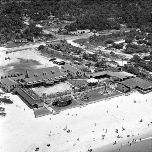
"Recovering Virginia’s African American Landscape,"
http://www.environment.cod.vt.edu/Posters/Originals/Deans%20Forum%20African%20American%20Poster.pdf
“Seaview Beach on Shore Drive in Virginia Beach and Sunset Lake in Chesapeake, Virginia”
http://freepages.history.rootsweb.ancestry.com/~howardlake/amusement12/seaviewbeachva.html
"Our heritage : Black history : Princess Anne County, Virginia Beach,Virginia”
“Historically African
American Beaches; Vanished Relics of an Uncomfortable Past,” 20 May, 2013
“We'll see you at
Seaview - July 1947,” The Virginian-Pilot, Jul 9, 2017
When Sea View Beach and Amusement Park closed, blacks could still not attend ocean front beaches as Jim Crow laws still stayed mainly in place. Between Sea View Beach and Seashore State Park (renamed First Landing State Park in 1997) Parker Beach became a popular beach as public places for blacks became scarce. From 1947 to 1971 Thomas Parker and his mother maintained a place for blacks to enjoy the Chesapeake Bay.
1933 - Ocean Breeze Beach and Amusement Park
The park was opened on 75 acres along the Chesapeake Bay alongside Lake Joyce for African Americans during this time of southern segregation laws. W.W. Consolvo, John C. Davis and Joseph Nelson (all white), opened Ocean Breeze May 30,1933. The 75-acre tract had bath houses and a dance pavilion between a dozen concessions selling ice cream, pop, hot dogs and hamburgers. Rustic furniture was located in shady spots affording a perfect setting for picnics. The Norfolk Southern Bus Company ran a frequent schedule from Norfolk to Breeze Beach for the very low fare of 35 cents round trip. 
1936 - First Landing State Park


Northern Most Ecosystem of
Spanish Moss Covered Bald Cypress

First Landing State Park's Trail Center
First Landing State Park's trail center at the south
entrance off of Shore Drive is the main hub for accessing the park trails (the
secondary access route for the trails is the 64th street entrance to the park).
Inside the trail center displays showcase local wildlife and area history plus
a meeting room for up to 45 people.
Just a few steps from the trail center on April 26, 1997 the
City of Virginia Beach and the Nansemond Indian tribe properly returned the
last 64 souls of Great Neck Point’s Chesepian (Chesapeake) Indians to their
rightful burial ground. A brief but solemn ceremony was officiated by Mayor
Oberndorf.

For information call 757-412-2320. This facility is maintained by the state. The nearby visitor's center at the entrance to the public beach is maintained by the City of Virginia Beach.
“City Commission Invites Public to Explore Preserving History of ‘America’s Cape’,” the American Standard, July 2015 https://amercorps.wordpress.com/2014/03/17/cape-history/comment-page-1
“Bald Cypress”
“First Landing State Park's Trails”
http://www.first-landing-state-park.org/first_landing_trails.html
1933 – Ferry Service Across the Chesapeake Bay.
The Virginia Ferry Corporation, a privately owned public service company, began
purchasing vessels that could be used to carry both passengers and vehicles
between the Delmarva (Delaware, Maryland and Virginia) Peninsula and Virginia
Beach, a 15 mile wide expanse of the Chesapeake Bay five miles from the mouth
of the Atlantic Ocean. During its peak, the Virginia Ferry Corporation operated
90 one-way trips each day from Cape Charles to Little Creek with seven vessels,
i.e.,
*S.S. Accomac built in 1928,
*S.S. Princess Anne built in 1932,
*S.S. Delmarva built in 1933,
*S.S. Pocahontas built in 1941,
*Virginia Beach built in 1944,
*Old Point Comfort built in 1945, and
*Northampton purchased in 1948.
In
particular Princess Anne passengers danced in the spacious ballroom or visited
the snack-bar on Fridays and Saturdays while traveling to Cape Charles as if on
a cruise line. The S.S. Princess Anne, white with a cobalt-blue streamlined
funnel, frosted windows and golden initials, would become a model for styling
future ocean liners and cruise ships. Upon arriving at Cape Charles, passengers
caroused on Mason Avenue lined with shops, eateries, wares, novelty stores, and
the elegant Palace Theatre with productions that included Annie and the Wizard
of Oz. In 1951 the Cape Charles terminus
was moved seven miles south to a new pier at Kiptopeke which shortened the 85
minute crossing by 20 minutes. This began a downturn for Cape Charles. Finally
the 1964 opening of the Chesapeake Bay Bridge Tunnel brought an end to the use of
ferries and added more recession to Cape Charles City which became an
off-the-beaten-path town several miles from the main north-south highway. But
the city experienced a rebirth in the 21st century. The town’s
cultural elements and beautiful scenery, combined with a laid back, small town
atmosphere, has encouraged an artist community to blossom with an influx of day
and overnight visitors with two Inns and three B&B’s.

The
above picture of the S.S. Pocahontas
is typical of the other six ferries. At one time, the Pocahontas, in honor of her name,
carried a flask containing earth taken from the grave of the Indian Princess
Pocahontas in Saint George's Churchyard in Gravesend, England.
Passengers enjoyed the dazzling success of that new
ferry "Princess Anne" and
danced or visited the snack-bar.
The History of Cape Charles
Historic Palace Theater
http://www.capecharlesbythebay.com/business/historic-palace-theatre
1940’s - Fish Nets

The holding area where pelicans leisurely fill their bills
Along Cape Henry are six fish net fences that lead fish into a holding area. Once a week the owners of the nets gather the fish not harvested by the pelicans. No longer permitted, these nets have been grandfathered, and once the fishermen die, that will be the end of the nets.

Mariners Mark (right) and Ocean Beach Resort Hotel (left) in the background
1960's Sand Replenishment on Chesapeake Beaches
The U.S. Army Corps of Engineers first became involved with Lynnhaven Inlet dredging in the early 1960's which requires full maintenance-dredging every four years with the sand spread between Ocean Park Beach (just west of the Lesner Bridge) and Cape Henry Beach (the stretch from Lynnhaven Inlet to First Landing State Park) on an alternate four-year cycle. The sand was to be pumped from a barge through large hoses laid along the beach. The sand would create a wider beach for protection of condos against storms while creating a more appealing beach to residents and tourists. For years Cape Henry Beach was deemed sand sufficient, and the dredged sand went only to Ocean Park Beach in 1987, 1991, and 1997 (other places included First Landing Sate Park Beach and the Ocean Front) .
In 2002 a City Beach Management Plan called for replenishment at Cape Henry Beach, and in 2005 the City Council passed a resolution to accept easements from residents to prepare for a 2006 sand replenishment project from dredged Lynnhaven Inlet sand. About one-third of the condo associations on Cape Henry Beach balked, saying their beach front was private and wide enough. Mike Batchelor, president of the Cape Henry Towers resident board, feared that a nicer beach would bring more people and traffic to the already-congested strip off Shore Drive. He said, "When any government agency comes courting with offers to help, we're very leery as to what it may cost us in the long run. We don't need it. We don't want it." Not all condo associations were against the sand replenishment. Andrew Barnett, former president of the Lesner Pointe East Association had been pushing to get the sand for seven years. He tried to persuade homeowner groups to give the city easements because he fears one major storm could seriously damage their homes. Barnett said, "Those of us who really need protection are held hostage by all of this." The Shore Drive Community Coalition, an umbrella group of civic leagues, tried to mediate between the city and resident groups, but made little progress. The one hurdle was the question of who owned the beach. Some condo associations believed they did. Don Clark, an attorney hired by the city to research title issues, said beaches are considered public unless a landholder can prove a deed dating back to the king of England. The city, however, didn’t want to get mired in title spats with land owners since the city's policy was not to put sand down unless all property owners agreed that a beach is public. In the end the 2006 Lynnhaven Inlet dredged sand went, once again, to Ocean Park Beach. Ironically, by August 2019 Ocean Park Beach needed more sand than any other along the Chesapeake Bay.
“Sand is stirring up friction at Cape Henry Beach,” by Richard Quinn, The Virginian-Pilot, Nov 5, 2006
https://pilotonline.com/news/article_9cfb4439-277e-592d-a554-20900bf46639.html The city made another plea to Cape Henry residents, this time in 2009 when dredging of Lynnhaven Inlet started again, this time on Cape Henry Beach, and as before, the call to halt sand replenishment work came from the Lynnhaven Dunes Condominium Association claiming in court their deeds showed that the beach belonged to them, but they were willing to give up their riparian (property) rights for $1.5 million. In a change from the past when Cape Henry lost out on sand, the court allowed the association to pursue their case while clearing the legal way for the Corps of Engineers’ contractor to continue with sand pumping on Cape Henry Beach. Not until October 15th, 2013, did a jury of the Supreme Court of Virginia decided Lynnhaven Dunes Condominium Association's water-access rights were worth nothing and the city should not have to reimburse the owners, a battle that cost the association a quarter of a million dollars. Even though the Corps of Engineers was cleared to have its contractor continue with sand replenishment operation, a November 2009 four-day nor’easter stopped all operations playing havoc on the beach. It damaged the Lynnhaven Pier, steps to the beach, and owners’ decks; leaving a trench in front of the 0.8 mile sea wall from Seagate Colony to Westminster Canterbury. The sand operation had enough sand to cover only part of the Cape Henry Beach from the Lynnhaven Inlet as far down as the Lynnhaven Pier, but because of all the storm damage, the city came through with an additional 50,000 cubic yards of sand (trucked in) between the Lynnhaven Pier and First Landing State Park.
“Va. Beach in Court over Cape Henry Beach Access” by Deirdre Fernandes
Mar 7, 2009, the Virginian Pilot
“Jurors Side with City in Virginia Beach Sand Lawsui”t, by Kathy Hieatt
Oct 16, 2013, the Virginian Pilot
"Virginia Marine Resources Commission Approves Truck-Hauling of Sand to Finish Cape Henry Beach Replenishment” February 5, 2010 -
“Sand men finish $2.4M dredge and replenishment project,” by Deirdre Fernandes, Feb 22, 2010, the Virginian Pilot

Damage steps down to Cape Henry Beach

Rebuilding Lynnhaven Pier Cost $500,000
Lynnhaven Inlet sand never reached beyond Ocean Park Beach as far as Chic’s Beach (running from "Joint Expeditionary Base Little Creek Beach" east to "Aeries on the Bay Beach Park") and year after year residents watched storm after storm whittle away at their beloved shoreline with some stretches as narrow as 10 feet at high tide or no beach at all. Then in 2014, since Cape Henry Beach waterfront property owners having already gone through "public beach" releases (Chic’s Beach had not), the Lesner Bridge contractor found a ready-made home for that 60,000 cubic yards of sand on Cape Henry Beach.

"Public Works Schedules Sand Replenishment for Cape Henry Beach," May 02, 2014
In Nov 2015 Chic's Beach residents stood in dismay at the southern edge of their diminished beach watching as Norfolk's Chesapeake beaches from the edge of Chic's Beach seven miles to Willoughby Spit were widened by 60 feet with 1.2 million cubic yards of sand worth $18.4 million and a promise from the federal government to replace washed away sand every nine years for the next 50 years using 70% of federal funds, all thanks to Hurricane Sandy’s federal money that flowed after that 2012 disaster. Missing out on these golden opportunities for sand, Chic’s Beach continued to be straddled with several beach front property owners still refusing to give permission to place sand in from of their properties on beaches they claimed to be “private property.” Bruce Mills and Bill Page used old planning documents that attested to the fact Chic’s Beach was never meant to be public, but then Mills and Page never complained about free trash pickups or beach patrols on their “private” beach.
In 2018 Chic’s Beach finally got sand. The affected Chesapeake Beach (locally known as Chic’s Beach) area extends about one mile along the Chesapeake Bay from Joint Expeditionary Base Little Creek-Fort Story east to Joyce Avenue. It took decades of planning and a court case to get critically needed sand for the rapidly eroding Chesapeake Beach. Storms destroyed the protective dunes and damaged backyard decks and other structures. Unlike the Ocean front, Chesapeake Beach, never has been on a regular replenishment schedule. It had been eroding for years, and the city couldn’t do restoration projects there because several property owners sued the city, saying the beach wasn’t public. They said the city would have to purchase easements to do a replenishment project. A lawsuit was resolved on May 25, 2016, when the Circuit Court ruled that Chesapeake Beach was public confirming the city had an easement that allows crews to add sand to the shoreline. The hold-out land owners were not happy and worried about non-residents, strangers, and other undesirables using what they had long assumed was their “private” beach. Bruce Mills was upset and told TV 10 WAVY News that “The city’s overreach is a violation of fundamental constitutional rights,” rights Mills and his supporters were willing to give up for more than $1 million. Paul Dimeck was also dismayed at the ruling and said it would bring more people and more cars. He told TV 10 WAVY News, “Where do they go to the bathroom?” worrying that the city might take the next step and install public toilets. The placement of sand took another two years for the city to come up with funding. When the Corps of Engineers received the lowest bid of $4.8 million, one million dollars had to be transferred from a fund for Oceanfront beach replenishment. The project finally got underway May 4, 2018.
“Chic's Beach Sand Replenishment Inches Ahead” Nov 29, 2014 http://hamptonroads.com/2014/11/chics-beach-sand-replenishment-inches-ahead
https://wtkr.com/2018/05/04/you-might-not-recognize-sections-of-chics-beach
In 2018 Chic’s Beach finally got sand. The affected Chesapeake Beach (locally known as Chic’s Beach) area extends about one mile along the Chesapeake Bay from Joint Expeditionary Base Little Creek-Fort Story east to Joyce Avenue. It took decades of planning and a court case to get critically needed sand for the rapidly eroding Chesapeake Beach. Storms destroyed the protective dunes and damaged backyard decks and other structures. Unlike the Ocean front, Chesapeake Beach, never has been on a regular replenishment schedule. It had been eroding for years, and the city couldn’t do restoration projects there because several property owners sued the city, saying the beach wasn’t public. They said the city would have to purchase easements to do a replenishment project. A lawsuit was resolved on May 25, 2016, when the Circuit Court ruled that Chesapeake Beach was public confirming the city had an easement that allows crews to add sand to the shoreline. The hold-out land owners were not happy and worried about non-residents, strangers, and other undesirables using what they had long assumed was their “private” beach. Bruce Mills was upset and told TV 10 WAVY News that “The city’s overreach is a violation of fundamental constitutional rights,” rights Mills and his supporters were willing to give up for more than $1 million. Paul Dimeck was also dismayed at the ruling and said it would bring more people and more cars. He told TV 10 WAVY News, “Where do they go to the bathroom?” worrying that the city might take the next step and install public toilets. The placement of sand took another two years for the city to come up with funding. When the Corps of Engineers received the lowest bid of $4.8 million, one million dollars had to be transferred from a fund for Oceanfront beach replenishment. The project finally got underway May 4, 2018.
“Chic's Beach Sand Replenishment Inches Ahead” Nov 29, 2014 http://hamptonroads.com/2014/11/chics-beach-sand-replenishment-inches-ahead
“Virginia Beach is $1 million Short for Chesapeake Beach Sand Replenishment,” Apr 2, 2018, by Mechelle Hankerson, The Virginian-Pilot
https://pilotonline.com/news/government/local/article_df050630-3101-11e8-96a0-57fd14c9607d.html “You Might Not Recognize Sections of Chic’s Beach,” May 4, 2018, by Mechelle Hankerson, the Virginian Pilothttps://wtkr.com/2018/05/04/you-might-not-recognize-sections-of-chics-beach

Area of proposed sand replenishment on Chesapeake Beach (Chic’s Beach)
In 2019, for the 3rd time Cape Henry Beach received sand (2009 & 2014). Beach replenishment for Cape Henry Beach started June 23, 2019 in conjunction with the Army Corps of Engineers’ Lynnhaven Inlet Maintenance Dredging project. Sand was placed 1.1 miles between the Lesner Bridge and Seagate Colony Apartments at 2830 Shore Drive. On August 8, after using all of the dredged sand, the operation was terminated leaving 0.8 miles between Seagate and First Landing State Park without the sand originally planed for that area. Normally sand replenishment only goes down Cape Henry Beach as far as Westminster Canterbury, but this year Cape Henry Beach got more sand as the result of additional Long Creek dredging.
Cape Henry Beach Replenishment update, June 24, 2019
https://sdcc.info/2019/06/24/cape-henry-beach-replenishment-update 
https://sdcc.info/2019/06/24/cape-henry-beach-replenishment-update


These pictures show the sand project on July 25, 2019 in front of Chesapeake Bay Shores Townhouses, two weeks before the project ran out of sand at Seagate Colony Apartments.


This map delineates the dredged area and corresponding proposed sand placement areas. It failed by 0.8 miles to reach the border of First Landing Sate Park.
1982 - Westminster Canterbury on Chesapeake Bay was opened and today is a 627-unit
not-for-profit retirement community sponsored by the Episcopal Diocese of
Southern Virginia and the Presbytery of Eastern Virginia. Designed for active
people age 62 and over with independent living, it also provides assisted
living and nursing care at a stable cost. To honor the church's original
mission, in 1992 Westminster-Canterbury established the Westminster-Canterbury Foundation
Fellowship Assistance Fund to a certain number of qualified individuals such as
people who have dedicated their lives to Hampton Roads and cannot otherwise
afford the initial move-in cost and monthly fees, both at the top price range
for this type of luxurious facility.
Westminster Canterbury on Chesapeake Bay http://www.wcbay.com


The Westminster Calendar Girls. Inspired by the 2003 film Calendar Girls, six Westminster Canterbury women, ages 73 to 83, decided to make a 2009 calendar by baring just enough skin to raise an eyebrow or two. The calendar became a big seller raising more than $13,000 for the Westminster-Canterbury Fellowship Assistance Fund.

“Westminster-Canterbury Calendar Girls Remain Young at Heart,” The Virginian-Pilot © Aug 19, 2008 http://hamptonroads.com/2008/08/westminstercanterbury-calendar-girls-remain-young-heart
Westminster Canterbury Notables
* Nancy Hoy,
widow of president of Norfolk Hoy Construction Harold "Hap" Hoy,
donated one million dollars to help
people financially unable to live in the retirement community. The
assisted-living wing is named after her.

* Isabel Marie Andrews
(1916 - 2003) felt the least she could do was organize 15 or so of her friends
to help greet Navy ships from the seawall in front of Westminster Canterbury as
they returned to the Norfolk Naval Station.
She knew when they would be coming from secret connections. Even when
her eyesight faded, she continued welcoming returning Navy ships with her
American flag waving.

Isabel Andrews welcomed countless
ships returning from deployment for eight years.
“92-Year-Old
Virginia Beach Woman Gives Homecoming Troops the Welcome They Deserve”
* Dr. Robert J. Stewart (1912 - 2014), a
retired podiatrist, led a productive, successful and happy life in spite of
having diabetes for 66 years. In his retirement at Westminster-Canterbury he
won five Gold Medals and set two world records in the Senior Olympics. He
promoted health and wholeness to residents, encouraging them to become more
active and eat right.

“Robert J. Stewart (1912 - 2014)”
“Taking
Control of Your Diabetes: A Practical Approach to Exercising For Life with
Diabetes”

1952 - The Duck-In
This was a
classic Virginia Beach seafood restaurant founded in 1952 when Bill Miller
bought the property. From its early beginnings it was a bait shack with a to-go
window where fishermen stopped to get tackle and breakfast sandwiches. Over the
years the little Duck-In grew and when Shore Drive was widened, Miller moved
the Duck-In 150 feet. Dredging of the inlet deposited more sand onto the
Duck-In beach, and by 1961, Miller owned more than 7 acres. His son, Bill,
renovated the building in the ‘80s to become a fully functioning restaurant. The
gazebo was a cornerstone in Cape Henry Beach, the center piece of weekly beach
parties, where literally hundreds of revelers began their weekend
festivities. Bands played for the party-goers
and diners.
In 2004 talk started about Duck-In
closing. The property had become too valuable for Bill to keep flipping hamburgers. There was also talk about moving the party to the Virginia Beach Resort Hotel, but
that never materialized when local resident around the hotel protested. In 2005 Bill closed the place, had it demolished, and moved to
Florida. The 7.6 acre lot sold in 2006 for an estimated $15 million. Citing
community concerns, developer, Tuck Bowie, downsized initial plans. In reality Bowie feared similar delays from local protests
over a nearby 122 acre development (now Pleasure House Point Natural Area) that
was going to turn wetlands into 1,063 homes, all nicely packed in.
Named Point Chesapeake Point on the Bay, five 4 story 3 bedroom beach front condominiums containing 40 units with a clubhouse for all is under construction to be completed sometime in 2017.
One remnant of the Duck-In would live on. The gazebo, built in the late 1980s, would be renovated. Bowie was sensitive to the fact that it should remain a silent sentinel to what once was. Adding to the sensitivity of the area Bowie's plans called for a public pathway under the Lesner Bridge to Vista Circle with places to sit and watch boats go by; a place for art displays at the scenic overlook on the southwest side of the bridge; and an art feature at the intersection of Shore Drive and Cherry Tree Place.
Timing was bad for the planned 2008 start of Chesapeake Point. The real estate market tanked, and plans were put on hold for eight years until late 2015 when a $1.5 million sea wall was constructed, and in March 2016 construction started.

Shortly after, the building was destroyed (above) making way for Chesapeake Point.

Point Chesapeake - rendering of the 5 four story (40 units) 3 bedroom beach front condominiums
(priced between $0.8 and $1 million), and Beach Pavilion (on the right almost under the bridge)
with existing gazebo on Cape Henry Beach (in front) to be restored
(priced between $0.8 and $1 million), and Beach Pavilion (on the right almost under the bridge)
with existing gazebo on Cape Henry Beach (in front) to be restored
The 40 Point Chesapeake condos will be shielded from busy Lesner Bridge by the 171 unit apartment Overture Point Chesapeake complex facing the bridge only 18 feet. Those facing Shore Drive were built specifically to limit noise featuring thicker walls, double insulation and sound-dampening windows. The apartments consist of one and two bedroom units for senior citizens (61+). They feature a pool, a rooftop lounge, a yoga studio, theater room, gym, resident garden beds, hair and nail salon, bocce ball courts, a coffee bar and bistro, salon, business center, and a kitchen used for cooking demonstrations. The complex will also offer daily activities, which could include small club meetings, wine tastings or movie events. Rents start at $2,210 and go up to $3,655. Units will be ready July 2017.
Update June 2019: Point Chesapeake condos have limited sales and after two years only two of the planned five planned five buildings have been completed. Overture Point Chesapeake apartments are fairing not much better with about 10% occupancy after opening a year ago.
"Living Near the
Lesner: New Virginia Beach Apartments Are Next To Reconstructed Bridge,"
the Virginian-Pilot, April 23, 2017
http://pilotonline.com/news/local/living-near-the-lesner-new-virginia-beach-apartments-are-next/article_59ea9c37-9b3f-5125-bbc3-7d3913a67544.html
“Condos, Apartments Going Up Where Duck-In Parties Were
Held in Virginia Beach,” the Virginian-Pilot
Mar 25, 2016 http://pilotonline.com/business/real-estate/condos-apartments-going-up-where-duck-in-parties-were-held/article_a6e44095-4839-50b9-8ce3-edea9db7839a.html
“Chesapeake Point on the Bay, Latest News,” 10 Nov 2016 http://pointchesapeakeonthebay.com
“Condos, Apartments Going Up Where Duck-In Parties Were Held in Virginia Beach,” Mar 25, 2016
“Chesapeake Point on the Bay, Latest News,” 10 Nov 2016 http://pointchesapeakeonthebay.com
“Condos, Apartments Going Up Where Duck-In Parties Were Held in Virginia Beach,” Mar 25, 2016
“Project for Duck-In Site is Back on the Drawing
Board,” The Virginian-Pilot, May 11, 2014
http://hamptonroads.com/2014/05/project-duckin-site-back-drawing-board
http://hamptonroads.com/2014/05/project-duckin-site-back-drawing-board
“Virginia Beach Connections - Duck-Inn History”
http://www.virginia-beach-connections.com/Online-Catalog.html 1956 – The Lynnhaven Fishing Pier

The 1480 foot long 20 foot wide pier was built on creosote piles driven 11 feet into the bay floor. The Pier Café is seen here with its bright blue canvas awning roof.
“Lynnhaven Fishing Pier being sold to retirement community,” by Stacy Parker, The Virginian-Pilot, Oct 3, 2017.
https://pilotonline.com/business/real-estate/lynnhaven-fishing-pier-being-sold-to-retirement-community/article_ee69a8ec-117b-5f01-ae2a-48544bcf3b63.html
2017 update: Westminster-Canterbury purchased the Lynnhaven Fish House and the Fishing Pier. The restaurant closed Dec 31 2017 and all but 100 feet of the pier was demolished.
1960's - the Lynnhaven Anchorage
Located directly in front of Cape Henry Beach, this was a holding area for foreign colliers (coal ships) and cargo ships waiting for their turn at Portsmouth, Norfolk and Newport News docks for loading, together known as one of the largest coal-export complexes in the world exporting more coal than any other U.S. port. Most of what the colliers load is metallurgical, or "met," coal, a raw ingredient for making steel. Unlike the old days when foreign seamen were a fixture in Hampton Roads, only those with U.S. visas can venture ashore when their ship docks to load. Companies chartering each ship pay about $17,000 a day. Some colliers must wait as long as a month for their cargo to arrive, and when global coal demands are high, twenty or more colliers can be seen at Lynnhaven Anchorage waiting for their port call. Those colliers, tall ships, an occasional aircraft carrier, and the night lights along the Chesapeake Bay Bridge-Tunnel (Lucius J. Kellam Jr. Bridge) made the view from Cape Henry Beach more than just a horizon, all that is seen from the ocean front.
Colliers waiting at the Lynnhaven Anchorage
“Coal Ships Create a Traffic Jam on Hampton Roads Waters,” Feb 21,2011 http://hamptonroads.com/2011/02/coal-ships-create-sight-hampton-roads-waters
“Freighters - Floating Foreign Islands - Wait off Virginia Beach”
http://hamptonroads.com/2011/07/freighters-floating-foreign-islands-wait-virginia-beach
 Captain Christopher S. Keane

On April 16th, 2014 wind gusts of more than 70 mph ripped collier ship Ornak’s anchor from the seafloor at the Lynnhaven anchorage and caused it to run aground just a few hundred feet from Seagate Colony at Cape Henry Beach. Before becoming mired in the sand the Ornak ripped apart a fish net structure (see above).
Cape Charles used to make profits from passenger ferry ships. Now their beach front is cluttered with coal colliers, the same ones that before April 2015 waited at the Lynnhaven Anchorage location until they were required to be anchored off Cape Charles causing an extra 30 mile, three- hour trip up the Chesapeake, and then an extra 30 mile, three- hour trip back to load coal. This has made a significant increase in expense for the coal colliers and the pilot boats. Why the change? Capt. Christopher Keane, who in June 2015 became commander of the Coast Guard’s Hampton Roads sector and the port captain, looked into federal regulations written in the late 1940s giving him discretion to permit merchant vessels to anchor at the Lynnhaven Anchorage. Even though current training is consistent with historical norms for off-shore exercises at the Joint Expeditionary Base Little Creek, East -Fort Story and even though there has never been any incident with colliers parked at the adjacent Lynnhaven Anchorage to these training exercises, Capt. Keane decided that ships in close proximity to naval exercises would impact the safety and security of his military people. Now with coal exports down due to a massive coal oversupply in East Asia, Hampton Roads’ chilling reception of coal colliers could not have come at a worst time with its competition vying for increased coal export among ports in New York, Baltimore, Savannah, Ga., Mississippi and Camden, N.J plus ports along the Gulf Coast.

"Navy Training Moves Coal Ships to Cape Charles," the Virginian-Pilot, May 2, 2015
http://hamptonroads.com/2015/05/navy-training-moves-coal-ships-cape-charles
"Coal Exports' Weak Start Locally Could Signal Trend,” The Virginian-Pilot, May 11, 2015
http://hamptonroads.com/2015/05/coal-exports-weak-start-locally-could-signal-trendOn April 16th, 2014 wind gusts of more than 70 mph ripped collier ship Ornak’s anchor from the seafloor at the Lynnhaven anchorage and caused it to run aground just a few hundred feet from Seagate Colony at Cape Henry Beach. Before becoming mired in the sand the Ornak ripped apart a fish net structure (see above).
1963 Photo of Virginia Beach
It showed features that have changed since. Ocean Shore Ave. ran 9 miles from the Lesner Bridge through Fort Story and south down to the Ocean Front. Today it runs only just a little over a mile through Chesapeake Bay Shores to First Land State Park but is chopped into a dozen pieces within neighborhoods. North Great Neck Road was London Bridge Road and swung behind the John B. Dey school and down what is now Thomas Bishop Lane. At Bay Lake Pines, Lake Joyce was much smaller. Apparently Rt 755 ran through First Land State Park (now a bike trail), and Fort Story had no gate and traffic could go through. Non-existent were the Lucius J. Kellam Jr. Bridge Tunnel (opened for traffic April 1964) and Northampton Blvd which replaced much of old Shell Rd as the main route to the bridge/tunnel. The intersection of First Court Road and Pleasure House Road was called Robins Corner.
“1963 Map of Northern Portion of Virginia Beach”

1963 photo - This is one of the first houses built in the area at the corner of Ebb Tide & Shore Dr Ave.
1964 – The Chesapeake Bay Bridge-Tunnel

“Dragados Awarded $756 Million Contract for
New Tube of Chesapeake Bay Bridge-Tunnel,”
“Thursday's (Feb 9, 2017) Fatal Truck Crash
Brings Death Toll on Chesapeake Bay Bridge-Tunnel to 79,” Feb 10, 2017 - http://pilotonline.com/news/local/transportation/thursday-s-fatal-truck-crash-brings-death-toll-on-chesapeake/article_db56819a-f2c6-5476-80ea-6452efb6851a.html
"Chesapeake Bay Bridge–Tunnel and Lucius Kellam Jr."
1970’s - Cape
Henry Trail
The old railroad
right-of-way became a trail (Cape Henry Trail) for walkers and sometime in the
70’s was paved for bikers. From its west starting access at Jade Street it runs
1.5 miles to First Landing State Park. At Hatton Street (mile 1.3) Lesley Harlow
built an eclectic garden in the early 60’s complete with a Norfolk Mermaid, ten
foot skeleton and suspended Dark Knight. (2019) - the current owner has taken all of these ornaments down.

 Crossing Kendall Street
the trail enters First Landing State Park and follows the rail line for another
0.4 miles of asphalt pavement before it diverges off the old rail line
following old Rte 343 / 755 for 5.5 miles to 64th Street (the
southern park entrance). From there Cape Henry Trail uses old Rte 343 for
a 1.5 mile mountain bike experience with lots of sand and patchy surfaces. It's
a rewarding little trek, with small hills, water views, and bird-watching. It
ends at the swimming and recreation area at the Narrows, a link of water
between Broad Bay and Linkhorn Bay. The VA Pilot dubbed it a Secluded
Beach Secret.
Crossing Kendall Street
the trail enters First Landing State Park and follows the rail line for another
0.4 miles of asphalt pavement before it diverges off the old rail line
following old Rte 343 / 755 for 5.5 miles to 64th Street (the
southern park entrance). From there Cape Henry Trail uses old Rte 343 for
a 1.5 mile mountain bike experience with lots of sand and patchy surfaces. It's
a rewarding little trek, with small hills, water views, and bird-watching. It
ends at the swimming and recreation area at the Narrows, a link of water
between Broad Bay and Linkhorn Bay. The VA Pilot dubbed it a Secluded
Beach Secret.
“First Landing State Park Is A Secluded Beach Secret,” July 17,2009
1977 - The Sea Wall
The 1.8 miles of Cape Henry Beach (from the Lesner Bridge east to
First Landing State Park) are split approximately in the middle by an 0.8 mile
sea wall built in 1977. On both sides of
the sea wall, communities are protected from hurricanes by sand dunes which
require setbacks from the beach and, in most cases, obstruct bay view from the
first floor. Communities behind the sea
wall have a grand view of the bay and access directly to the beach. These
communities and businesses include (from west to east) Lesner Point East
Condominiums, Lynnhaven Beach Condominiums, Westminster-Canterbury on
Chesapeake Bay, Casa Del Playa Condominiums, Lynnhaven Fish House/Pier Cafe and
Pier, Ocean Shore Condominiums, Ships Watch Town Homes, Chesapeake Bay Shores
Town Homes, and Sea Gate Colony High Rise Condominiums. Cape Henry Beach has a total of
22 public access paths. The seven that step down from the sea wall are paved
and afford lots of free parking along Ocean Shore Avenue and three cul-de-sacs
in Chesapeake Bay Shores. Those 15 access points on either side of the sea wall
have very limited parking with one concrete (partial) and three plank paths,
one of which is a handicapped access (at the end of Sandalwood Road). The
others are sand. The three high rise condominiums are Harbour Gate and Cape
Henry Towers near the Lesner Bridge and Sea Gate Colony just west of Virginia
Beach Resort Hotel and Conference Center. Ships Watch and Chesapeake Bay Shores are the
only town homes. The sea wall is composed of 3
x 15 foot tongue and groove precast reinforced concrete sections with a 1 x 1.5
foot concrete lip. Sections were anchored 8 feet into the sand using water
jetting, a method of sinking wall sections with high pressure water.
One of 24 Chesapeake Bay
Shores town homes situated behind the sea wall
with a grand view of the bay and direct access to the beach1978 – Low Rent Regatta.

The "Low Rent Regatta" (Picture from "Gone but not Forgotten,VA Beach,"
by Jordan Shepherd and James Jordan IV, 2008)
In mid-July at a Hobie 32 Fleet
meeting (catamaran sailors), the Chesapeake Beach crew was chastised because
they could not afford to participate in an upcoming regatta. An offhand comment
noting their “low-rent district” ignited what would become a 20-year
inexpensive fewer-rule Low Rent Regatta with proceeds of nearly $250,000 given
back to the community. It was 26-miles, north and west through the first
Chesapeake Bay Bridge-Tunnel opening, north and east through the second opening
and back to shore. The Labor Day event saw hundreds of Hobie Cat entries, preceded
and followed by wind-surfing, volleyball tournaments, and parties - all hosted
by the Fort Story Officers Club on their beachfront for the last 15 years of
the event. In 1984 Virginia’s Governor,
Chuck Robb, showed up to award trophies. In its heyday as many as 189 boats
raced. With the waning popularity of catamarans, insurance, and city
regulations, after 20 years the 1998 Labor Day weekend was the final race
coupled with a final party celebration. The Low Rent Regatta was one of the
largest and longest-running catamaran races ever held and left lasting
friendships among communities up and down the Chesapeake beaches. On Sept. 9,
2017 a Low Rent Regatta 20 year reunion was held at Bouy 44. Boaters
and onlookers of the bygone Labor Day sailing event came together to celebrate
and remember.
“ ‘The more beer we drank, the better the idea
became’: Beach sailors remember Low Rent Regatta,”
1986 – The Virginia Beach Resort Hotel and Conference Center
Becomes the Delta Hotel by Marriott
At 2800 Shore Drive, the hotel opened in 1986 becoming the only hotel in Virginia Beach on the Chesapeake. VBRH&CC provided sunset views from 295 suites. Featured was the Tradewinds Restaurant, in &
outdoor pools, a fitness center and coupons to play tennis at nearby Virginia
Beach Tennis and Country Club. A summer
concession in front of the hotel rented various non-motorized water craft. A Segway outlet featured rides on Cape Henry
Trail. The hotel provided an option for young
groups that needed a place away from the hustle and bustle of the beach front
with calmer waters.

From left to right on the ground floor – outdoor pool, indoor pool, patio bar, Tradewinds Restaurant with deck under the striped awning and the Sunset Ballroom under the sloped roof.
The hotel’s biggest moneymaker was hosting wedding ceremonies on the beach along with receptions, rehearsal dinners, luncheons and room rentals.

Typical setup for a wedding out in front of the hotel
Not long after its opening the hotel spent $1 million renovating Tradewinds Restaurant and building a ballroom. Ballroom plans showed a flat roof so that next door Mariner's Mark Condominiums would not have an obstructed view of the beach. But a sloped roof was built instead which obstructed the view for several of Mariner's Mark units. This began an unfriendly association with local neighbors. Next up were plans to build a 980-square-foot gazebo on Cape Henry Beach. Included in the zoning petition was license for bands which were playing at the Duck Inn (soon to closed). Residents came out in large numbers to a hearing on the hotel’s proposals in January 2005. With strong opposition the hotel put off plans for the band and gazebo.
Hotel ratings have been a mixed bag from “an unforgettable stay” to “a miserable experience.”
For years a summer concession of the VBRH&CC Hotel rented out jet skis. They were noisy and dangerous to swimmers, just one more hotel operation creating sour relations with neighbors. The jet ski controversy was finally brought to a head in 2007 by local resident Ray McDaniels who cited various code violations. He was instrumental in having them banned from the beach.

Ray McDaniels led the fight to get jet skis banned from the beach.

Update: The hotel was closed in late 2018 and sold to the Marriot Corp. Throughout 2019 and 2020 major renovation have taken place and reopened March 22, 2021 as the Delta Hotel by Marriott, a full-service hotel. Bayfront dining at the Tin Cup Oyster Bar and Grill replaces the Tradewinds. Call 757-481-9000 for reservations.
https://www.marriott.com/hotels/travel/orfdb-delta-hotels-virginia-beach-bayfront-suites
1990’s Colorful Characters at Cape Henry Beach
Cape Henry Beach has always had its colorful characters being a beach free of police enforcement, a place where dogs can run free and kids don’t have to worry about the huge ocean waves.Louis Perna II (Lu) lived in a cardboard box on Cape Henry Trail near North Great Neck for approximately 5 years in the 90’s taking walks with his dog on Cape Henry Beach.

“Goad: 'He Chose The Life He Wanted To Live'”
Beach Bill took walks in the 90’s for many hours every day along the shores of Cape Henry Beach – always with his wide brim hat and a can of beer in his hand.
Beach Bill, Salon Marketing - http://www.beachbill.com 
Beach Bill’s Daily Stroll on Cape Henry Beach
|
“A Perfect Four-Mile Walk: Cape Henry Beach”
http://shorelinesblog.visitvirginiabeach.com/index.php/2012/02/28/a-perfect-four-mile-walk-cape-henry-beach
1957 - Lynnhaven Bridge Becomes Lesner Bridge
First called the Lynnhaven Bridge, it was built across the Lynnhaven Inlet at the mouth the Chesapeake Bay. The first bridge for automobiles, a draw-bridge was constructed in 1928 next to the train trestle. It was replaced in 1957 by a two lane spans and renamed the Lesner Bridge after John A. Lesner, a Democratic Virginia State Senator who represented Norfolk City and then served on the State Highway Commission beginning in 1908. Westbound lanes were constructed as a parallel span in 1966. 
The new Lesner Bridge opened to traffic on May 30, 1958. The older draw span is visible to the left of the new bridge. From Virginia Beach in Vintage Postcards by Alpheus J. Chewning, 2004
The 21st Century

Rendering of the Lesner Bridge Structure originally scheduled to be completed June 2017
2003 - Early Stages of Planning a Replacement. The bridge deck was found to be structurally deficient with the bridge piers judged to last another 50 years. Nevertheless, it was decided to replace the entire bridge. In 2005 the city asked residents
to vote on two possible alignments. Since most residents live on the north side
of Shore Drive, the overwhelming choice was a right-of-way calling for the
bridge to be built in two steps, first
a new east bound bridge south of the existing bridge and then demolition of the
entire bridge so the west bound lanes could be built in the footprint of the
old bridge. This construction allowed for four lanes to remain open during
construction since the single new 40 foot wide bridge could temporarily handle
four traffic lanes. Dimitri Hionis (owner of Bubba's Restaurant, the
Lesner Inn and a shellfish company) worried about losing parking space and the
Maryland and Virginia Pilot Association worried about traffic noise for the pilot
boat employees’ sleeping quarters which would end up closer to the new bridge. Further, the argument was made that the south alignment would cause the high voltage power lines to the south of the bridge to be replaced. Estimates ranged
over $20 million, but there was no consideration of placing the lines inside the
box girder space of the new bridge, a relatively inexpensive and eye pleasing
alternative. Was this a ruse to justify the northern option that is close to
existing housing? With these two arguments the City Council agreed in early May 2009 on the northern option, i.e., the west bound lane bridge would be the first built, bringing the
northern alignment within 18 feet of the new Overture at Chesapeake Point apartments. Dorinda
Ennis, a 3556 Condominium condo owner on the west side of the river said, "The northern alignment takes a premier
building, ours, and squishes it near the bridge. It was very disappointing." A 2012 Charette (planning meeting) was supposed to present various plans to citizens, from Spartan to luxurious. But instead, the designers had practically finished the design of a luxurious replacement bridge. The meeting was simply to ask citizens what railing and lamp posts they liked best. Attending the meeting were local citizens who were enthusiastic about their future “Cadillac” bridge.
Cadillac Bridge. With over 21,000 bridges in Virginia there are over 1,200 structurally deficient and over 3,000 functionally obsolete. This danger lingers because the federal government hands out highway funds to states with no restrictions on how they spend the money.
The Lesner Bridge is a shining example. The 1,575 ft bridge over the Lynnhaven
inlet will still provide 4 traffic lanes (2 each way) but will be 15 feet
higher and each bridge 20 feet wider to accommodate extra wide shoulders and multi-use
paths; luxuries preventing money for other bridges in need. At $115 million the cost of the Lesner Bridge replacement is more than 6
times the cost of the Old Lesner Bridge which was built for $1.1 million (1957)
and $1.2 million (1966) or $18.2 million in 2017 dollars. The bridge deck was designed with precast box-girders, 14 between two piers, held in place by an overhead gantry until steel rods are strung through holes in the box-girders and pulled into tension. If these box girders are damaged, repair is going to be very, very expensive since the whole section from pier to pier would have to be replaced. In a storm a barge could accidently ram into the bridge (as has happened to the Chesapeake Bay Bridge Tunnel).
Botched Estimate. As things turned out the city got burned by the
engineering consultant, Clark Nexsen International Architecture and Engineering
Consultants “that botched its estimate,”
and its $89 million cost estimate ended up at $115 million. Since the
state and feds refused to kick in additional money, the city had to pony up the
additional $26 million.
Construction Delays. Work started Jul 2014, and the two spans were
originally scheduled to be fully operational June 2017, but that date slipped a year and a half past June 2017. Each day the project was
late, the city leveled $3,200 in “liquidated damages” to the builder, McLean
Contracting, for not finishing on time. This added up to about $1.7 million dollars. One delay occurred at the initiation of the project when the overhead gantry arrived from Italy. The assembly instructions were in Italian holding up progress for over a month while they were translated into English. Nothing has been printed in the papers about what the final liquidated damage assessment was (or the final cost).
Design Flaw. As the wood guard rails begun to be installed, the city inspector was warned about their improper placement. They were being placed too near the concrete curb. Vehicles driving too close to the shoulder should hit the curb first warning them to steer away to the left. By hitting the rail first, damage is caused to both vehicle and guard rail costing both the state and vehicle owner thousands of dollars in repair. For the first year there were four vehicles hitting the wood rail, with one smashing in to the end post. Damage to the rail and vehicle could most likely have been prevented if the guard rail had been set back a foot from the curb. Further, guard rails at the entrances to the bridge have no sloped wood rail section allowing the vehicle to slide up causing much less damage to the vehicle. This type of sloped rail was installed a half mile to the west on the east bound lane on the right side over Pleasure House Creek. In June 2019, at the entrance to the Lesner Bridge, the west bound lane guard rail was severely damaged along with major damage to the vehicle. Instead of a sloped rail stopping the vehicle gradually, the impact stopped the vehicle almost instantly with passenger injuries.
Design Flaw. As the wood guard rails begun to be installed, the city inspector was warned about their improper placement. They were being placed too near the concrete curb. Vehicles driving too close to the shoulder should hit the curb first warning them to steer away to the left. By hitting the rail first, damage is caused to both vehicle and guard rail costing both the state and vehicle owner thousands of dollars in repair. For the first year there were four vehicles hitting the wood rail, with one smashing in to the end post. Damage to the rail and vehicle could most likely have been prevented if the guard rail had been set back a foot from the curb. Further, guard rails at the entrances to the bridge have no sloped wood rail section allowing the vehicle to slide up causing much less damage to the vehicle. This type of sloped rail was installed a half mile to the west on the east bound lane on the right side over Pleasure House Creek. In June 2019, at the entrance to the Lesner Bridge, the west bound lane guard rail was severely damaged along with major damage to the vehicle. Instead of a sloped rail stopping the vehicle gradually, the impact stopped the vehicle almost instantly with passenger injuries.
Colorful Lights under the Bridge. Drive into Bubba's Restaurant parking lot some night and look at the colorful lights under the bridge. Too bad this colorful display is only visible to boaters and restaurant folks.
What’s in a Name? The Lesner Bridge (named for
State Senator John A. Lesner’s State Highway Commission service) was named the
Lynnhaven Bridge when it was a draw bridge before 1958. At the beginning of
construction the city felt the time had come for a new name. In February 2016, supported by the local newspaper, suggestions came in to rename the bridge in honor of US
Navy Admiral Jeremiah Denton or change it to its commonly known name of
Lynnhaven Inlet Bridge. Local residents and the Lesner family oppose the change
and a public poll resulted in no support for the name change.
Note: The Chesapeake Bay Bridge-Tunnel (CBBT) was named the Lucius J. Kellam Bridge (name didn’t stick). Sea Shore State Park was renamed the First Landing State Park in 1999 (name has stuck but not for old timers in the area).
Note: The Chesapeake Bay Bridge-Tunnel (CBBT) was named the Lucius J. Kellam Bridge (name didn’t stick). Sea Shore State Park was renamed the First Landing State Park in 1999 (name has stuck but not for old timers in the area).

Three of the 14 box girders for the first bridge span
One of the new twin bridges, 53 feet in width, will
temporarily accommodate four vehicle lanes (two each way), while the old twin
bridges are demolished, making way for the east-bound new bridge. Each new span
features two 12-foot traffic lanes, a 6-foot inner shoulder and a 10-foot outer
shoulder, wide enough for 3 lanes, but wait! Shore Drive is a four lane
highway, but for how long.The Canoes at Lesner Bridge in Ocean Park

This water color will be looking east over the new Lesner Bridge
In Oct 2018 on the Ocean Park side of the new Lesner Bridge a new aluminum sculpture created by Donald Lipski was installed. It is a 26' wide by 46' tall starburst of ten canoes with LED lighting that provides an inviting evening tmosphere. Lipski’s idea for the canoes came from the first type boats to cross through the Lynnhaven Inlet. Adam Keeling, whose plantation was situated east of today’s Lesner Bridge, in August 1667 organized a group of people to dig a small pilot channel from the Lynnhaven River through a huge sandbar about a half-mile long to the Chesapeake Bay so boats would not have to make the long journey west to the mouth of the river which at that time was at Little Creek where today’s Joint Expeditionary Base Little Creek is located. The trench dug was wide enough for a small boat (Lipski’s visualization was of a canoe) to paddle through the channel. A month later on September 6, 1667, the dreadful hurricane of 1667 struck, a storm considered one of the most severe hurricanes to ever strike Virginia. It forever changed the course of the river widening the little pilot channel to the Chesapeake. Installation of the sculpture is not expected to be in the way of ongoing bridge construction. “Lesner Bridge” - http://en.wikipedia.org/wiki/Lesner_Bridge
“Lesner Bridge” - http://en.wikipedia.org/wiki/Lesner_BridgeDelicate, but strong: New canoe sculpture will rise from Lesner Bridge in Virginia Beach, July 20,2018
https://wtkr.com/2018/07/20/lesner-bridge-the-canoes-sculpture-to-be-dedicatedDelicate, but strong: New canoe sculpture will rise from Lesner Bridge in Virginia Beach, The Virginian Pilot, 23 April, 2017
http://pilotonline.com/entertainment/arts/delicate-but-strong-new-canoe-sculpture-will-rise-from-lesner/article_5962f8d3-4e67-59c7-836b-14bc58a65552.html
http://pilotonline.com/entertainment/arts/delicate-but-strong-new-canoe-sculpture-will-rise-from-lesner/article_5962f8d3-4e67-59c7-836b-14bc58a65552.html
Lesner Bridge construction (start to
finish) on YouTube (2-1/2 min)
http://pilotonline.com/news/local/work-continues-on-new-lynnhaven-inlet-span/article_c94622be-714c-5e1b-b3ed-c0126fecacbf.html
Bridges in Virginia, 2016 http://www.virginiadot.org/info/bridge.asp
Beach Can't Close Gap over Site for New Lesner Bridge
Lesner Bridge Low Bidder Wants Out after $20M Mistake - January 8, 2014
Beach Is Finally Ready to Build New Lesner Bridge
“Lesner Bridge is months behind, but new span expected to open in late October,” Oct 6, 2016
2005 - Crabbing
Began by mostly Fillipino crabbers catching blue
crabs at Cape Henry Beach from May through September, they used chicken necks as
bait and scooped the crabs up in nets. 
2006 - Cape Henry Kiteboarding.
In the late 1990’s in Oregon
Cory Roeseler developed an inflatable tube kite harnessed to a rider on a small
surfboard - the kite propelling the rider across the water. If the kite
dropped down to the water it would easily bounce back into the air. Corey’s
invention, called kiteboarding or kitesurfing, took off in the Columbia River Gorge in Hood
River, Oregon, where wind conditions were favorable most of the time. Not until
2006 were one or two kiteboarders seen on windy days off Cape Henry Beach, but
by 2014 dozens of Cape Henry kiteboarders were jumping waves.
2006 - First time kiteboarder trying out in calmer waves.
The Lynnhaven Fishing Pier in the background.

2014 - dozens of Cape Henry kiteboarders jumping turbulent waves.
Looking east toward First Landing State Park BeachThe History of Kiteboarding & Launch of a New Sport http://www.inmotionkitesurfing.com/2013/history-of-kiteboarding
2007 - Indigo Dunes Becomes
Pleasure House Point Natural Area
Local citizens have long spearheaded efforts to raise funds for purchase of undeveloped waterfront property on the Lynnhaven River known as Indigo Dunes. The property is located on the north side of Pleasure House Creek and Crab Creek. It is 122 acres of beautiful undeveloped coastal property encompassing oyster beds, wetlands and a maritime forest. In 2007 L.M. Sandler & Sons bought the land for $30 million. They proceeded to get approvals to build 1,063 homes on the land, offering to trade these wetlands for land they owned in Florida, but the housing market bottomed out in 2009 and Sandler defaulted on the loan. This opened the way for a purchase in July 2012 of the property for a bargain basement $13 million with help from the Trust for Public Land, the Chesapeake Bay Foundation and the community. The Chesapeake Bay Foundation’s (CBF) helped in the purchase of Pleasure House Point in exchange to be allowed to place one building near the north side property line out of the way of the natural area. The building is a state of the art CBF regional headquarters and education center, promoting preservation and sustainability to teachers and students. There are rooms for local conservation groups and community organizations. Opening on January 5, 2015 the Brock Environmental Center is named in honor of Joan and Macon Brock of Virginia Beach, who generously donated $3.6 million toward the $21 million project. The 10,000-square foot building was the first Leadership in Energy and Environmental Design (LEED) Platinum certified building in Virginia, a green building rating system. Its natural brown wood siding sitting on pylons allows natural sand to flow under it to blend with the natural surroundings. On May 13, 2016, the center was honored for becoming one of the first 11 projects to meet all of the criteria required under the “Living Building Challenge” by the International Living Future Institute,
considered by many to be the highest honor in the world for green building projects. The Brock Center is the first building in the South to earn it. Among the center’s distinctions is the first-ever system in a U.S. commercial building for making all drinking water from rainwater. It generates all of its own electricity from solar panels and two wind turbines.
Virginia Beach's Brock Center One of the First Buildings in the World to Earn Elite Green Honor,
The Virginian-Pilot, May 12, 2016
Indigo Dunes Becomes Pleasure House Point Natural Area
Treasure at Pleasure House Point – The Virginian Pilot, July 12, 2013 http://hamptonroads.com/2013/07/treasure-pleasure-house-point
Brock Environmental Center
Pleasure House Point

Indigo Dunes Becomes Pleasure House Point Natural Area
http://www.vbgov.com/government/departments/parks-recreation/design-development-projects/current-projects/Pages/pleasure-house-point.aspx
Pleasure House Point, Brock Environmental Center http://cbf.houriganconstruction.com/about
2009 - Joint Expeditionary Base
Little Creek-Fort
Story (JEBLC-FS)
After
WWII Fort Story was occupied by the Army for use in training amphibious units. As
a result of a 2005 Base Realignment and Closure recommendation, on October 1,
2009, Fort Story operations were transferred to the Navy merging with Naval
Amphibious Base Little Creek (JEBLC) to officially became Joint Expeditionary
Base Little Creek Fort Story (JEBLC-FS), the first joint base in the Hampton Roads,
VA area. Their primary mission is to transport US Marines to trouble spots
around the world on Landing Platform Dock (LPD) ships, each housing two
air-cushioned landing craft (LCAC) (hover crafts) which can deploy to the beach
180 troops or an M-1 Abrams tank. Beside personnel and equipment delivery, LCAC
have proven to be very useful in supporting non-hostile amphibious operations
and were vital in delivering life-saving equipment, food, water, and medical
supplies in humanitarian relief efforts after disastrous floods in Bangladesh,
Indonesia, and Pakistan and the devastating earthquake in Haiti. Four of the
eight Landing Platform Dock’s (LPD), now operational (one still under
construction) are based at Norfolk Naval Base. They conduct training operations
off Ft Story where locals are more than aware when they train due to the high
volume of noise LCAC’s generate. https://en.wikipedia.org/wiki/Landing_Craft_Air_Cushion

USS San
Antonio (LPD-17)

An LCAC aboard the USS San Antonio (LPD-17)

Marines exit the LCAC during
an exercise

An LCAC skimming along at 40
knots using an average of 1000 gallons per hour, a real bargain considering that
an F-16 fighter jet uses 1,680 gallons of fuel per hour.
2011 - Paddleboard Mileage Record
Mike
Simpson and Will Rich of Rhode Island left Virginia Beach on their stand-up
paddeboards on their 1,600 mile journey from Key West, Florida to Portland,
Maine to raise awareness and money for the SUP Clean-Up and Wounded Warrior Project
charities. About a dozen folks were on hand to see them off. Coming into Virginia Beach on Monday, May 16th,
they encountered giant swells as they attempted to cross the mouth of the
Chesapeake. They reached the Chesapeake
Bay Bridge-Tunnel and found a boater willing to take them back to shore. The
boat dropped them off at the Virginia Beach Resort Hotel & Conference
Center where they stayed for three nights. On June 30, 2011, 42 days after
leaving Virginia Beach, they arrived at their final destination, Portland,
Maine. Their 1,600 mile journey will surely be the folklore of paddleborders in
years to come.
Arriving in Portland Maine June 30,
2011, Just after Paddling Through Dense Fog.
Another couple on their stand-up paddleboards, attempting a
bit shorter route, arrived in Virginia Beach Nov 17th, 2015 from New
York on their way to Florida. Called “Atlantic
Supergirls” – LouAnne Harris, 28, and Julieta Gismondi, 30 started their
trip Oct 12th, paddling
to raise money for Mission Blue, an ocean-conservation organization, and First
Descents, a program that provides outdoor adventures for young adults affected
by cancer.
“Chesapeake Bay Challenges Philanthropic Paddlers”
2012 - Tall Ships at Lynnhaven Anchorage
On June 7th, tall ships rendezvoused at Lynnhaven Anchorage, making ready to sail into Norfolk the next morning for the Parade of Sail OpSail 2012. The ships’ masts were lit up, making a spectacular night time view off Cape Henry Beach.

Dozens of Tall Ships, with lights strung from bow to stern at the Lynnhaven Anchorage,
just off Cape Henry Beach, make a grand nighttime display.
Tall ships from around the globe sailed from Cape Henry to downtown Norfolk to kick off a weekend of festivals.
2012 - Pelican Rescues @ Cape Henry Beach

The above picture (2012) shows the rescue of a pelican trapped in the above fish nets. After exhaustive struggle to get free, the pelican offered little resistance. It was placed on the kayak and paddled to shore for the wildlife rescue folks.

The above picture shows a Virginia Beach SPCA wildlife rescue operation of a young pelican at Cape Henry Beach. After being netted, the pelican was wrapped in the blanket shown here and carried to a van where it was caged for the ride to the rescue center. (Sep 2016).
2014 - Fire Kills Couple Born on Same Day
On April 13th Lynnhaven Beach Condominiums caught fire right next to Westminster-Canterbury on Chesapeake Bay. All 22 residents escaped except Benjamin and Patricia Joyce (April 23, 1929 - April 13, 2012) who were born on the same day and would die on the same day. They had been married 62 years. Their children’s advice to move to assisted living facilities went unheeded as they loved where they were, looking out at Cape Henry Beach each morning.
“Two Seniors Dead in Condo Fire in Virginia Beach,” April 14,2012

From the Old Donation Episcopal Church 2009 Picture Book

Outdoor Gas Barbecue Pit Fire Destroys Two Buildings at Lynnhaven Condos April 13, 2012
2016 - Flags at Entrances to Communities

An expenditure of roughly $104,000 in the city budget
saw the erection of five sets of four flagpoles with colorful banners marking
the entrance to the Bayfront Communities along Shore Drive and North Great Neck
Road. This was part of efforts to beautify the area from funds
earmarked for Shore Drive improvements to sidewalks, drainage and traffic.
The Cost of Pretty
Flags, by Kerry Dougherty, The Virginian-Pilot, Jul 15, 2016
http://pilotonline.com/news/local/columnist/kerry-dougherty/dougherty-the-cost-of-pretty-flags/article_c62b209b-398d-5d31-a78a-2fe52bd384f0.html
Bayfront
Advisory Commission - https://www.vbgov.com/government/departments/planning/boards-commissions-committees/Pages/Bayfront-Advisory-Commission.aspx
July 4th 2016 Celebration at Cape Henry Beach


Continuing a yearly celebration, the evening of the 3rd was in front of a Whaler Court deck featuring a top local band for the benefit of the Wounded Warrior Foundation. All was peaceful.
May 26, 2018 - Floatopia
Two years later at Ocean Park Beach, all was not so peaceful. Hosting 500-1,000 people at Ocean Park (between the Lesner Bridge and Water Oaks
Beach along Jefferson Blvd) for several years it had been a pleasant gathering of beachgoers and
boaters meeting on a quarter mile stretch of shoreline for a party. They
brought anything and everything that would float. Some came by sea and others
by land. They set up tents, started up grills, and filled coolers with beer.
They anchored boats and played in the water.
Thanks to social media and word of mouth, the May 26, 2019 event
brought more than ten times the 2018 crowd. With over 10,000 people things
went poorly. For
starters, they left tons of trash when they were finished, 10 tons of it.

Not
only did two women leave trash, but they left their kids, an infant and seven-year-old
were found dehydrated and overheated. There were drunks and fights. Without any bathroom,
people named the beach “pee-topia."
“Norfolk Mom Charged With Being Drunk, Abandoning Children at Floatopia in
Virginia Beach,” the Virginian Pilot, May 30, 2019
"No Permits, No
Security": Floatopia Event Angers Ocean Park Beach Residents, the
Virginian Pilot, 30 May, 2019
September 2019 - The Saga of the Totem Pole


For weeks the trash truck failed to pickup a large log that had washed up onto Cape Henry Beach. Finally it ended up as a work of art. People came to admire the artwork taking pictures standing beside it, one person even climbing to stand on top.

For weeks through several storms and high tides, the totem pole stood tall. On October 19th, 2019 the trash truck that had ignored this piece of wood that had languished for months, both rolling in the tide and then embedded in the sand, was now thought to be a danger by the city and had to be hauled away.
 Rushing to its defense, as the trash truck was starting to haul it away, the artists who had painted the totem pole, asked the trash truck crew to haul it up in front of their property, where it will hopefully weather future storms. -------------------------------------------------------------------------------

For weeks through several storms and high tides, the totem pole stood tall. On October 19th, 2019 the trash truck that had ignored this piece of wood that had languished for months, both rolling in the tide and then embedded in the sand, was now thought to be a danger by the city and had to be hauled away.

Vacation at One of Three
Virginia Beach Beaches
The
city of Virginia Beach is now promoting “Three Beaches, One Vacation” -
the Ocean Front, Sandbridge, and Chesapeake Beaches. Of these three, the city is offering the lest enticement to come to the Chesapeake beaches; but that's fine with the locals and tourists who have discovered the free parking; gentler waves; no sharks; no long trips over 400 feet of hot sand; no long waits at some of the best VA Beach restaurants; many access sites; warmer waters late into October; close-by grocery, drug and hardware stores; a beach away from the riffraff; more interesting views out into the Chesapeake Bay with its container and military ship traffic lanes plus the lighted Chesapeake Bay Bridge night lights; soon to open the new Delta Hotel by Marriott (June 2020) and much more (read on). http://www.first-landing-state-park.org/first_landing_swimming.html

Sunrise over Ft Story as seen from Cape Henry Beach

Sun up -
Sun Down – Since Chesapeake beaches are facing
north, one can see the sunrise and sunset in the summer time, a big plus that
the Resort Area and Sandbridge Beaches don’t have. Vacationers flock to Mallory
Square in Key West, Florida, to celebrate the sunset and up in Maine, they
drive up Cadillac Mountain to see the nation's first sunrise. Chesapeake
beaches have both and they’re usually gorgeous.

Dog
Beach – All along
the Chesapeake beaches dogs don't need to be on a leash, but they do need to be
under control, licensed and up to date on their rabies vaccinations; however,
from Memorial Day to Labor Day, they are banned between 10 am and 6 pm (the
sand’s too hot anyway).
“Dogs on Cape Henry Beach Don't Need to Be on a Leash,” July 5, 2012
"Carolina Dog" - http://1bob1.blogspot.com/2010/04/carolina-dog.html


Kid
Beach. Because of
the gentle waves and water depths not
over four feet until around 40 feet out into the bay, it’s the perfect beach
for kids.

Family
Beach. There are
many reasons families are discovering Cape Henry Beach compared to the Ocean
Front – less hassle, free parking, gentle waves, shallow waters, easy
access (especially for rubber ducky and paddle boards), and no beach patrols
around to hand out tickets for what you’re wearing or not wearing or what’s in
your cup. When it’s time to leave the beach that never closes, there’s
fun and eats for the whole family at very reasonably priced family establishments
like McDonalds, Dunkin' Donuts, plus dozens of restaurants (listed below). ShoreBreak Pizza and Billiards @ 2941 Shore Dr (757) 481-9393 will even bring the food to you on the beach (just
tell them the street name of the public access) http://www.shorebreakvb.com
Free Parking with a short walk to the
beach. If you are spending the day, there are no public restrooms except
at First Landing State Park Beach ($5 per vehicle on weekdays and $7 on
weekends). Folks at Cape Henry Beach
have found restroom access at one of the many close-by restaurants.
Shore Drive Parasail - Dockside Fishing Center - 3311 Shore Drive - 359-8442

Dolphin Watch Sunset Cruise. Experience life like
never before with dolphin-watching trips from Dockside Seafood Ramp in Virginia
Beach. Sunset cruises on Virginia Beach last approximately an hour and a half
and depart nightly, except Monday nights at 6:30pm beginning Memorial Day thru
Labor Day. http://www.fishingvabeach.com/dolphin


Premium Restaurants featured on the Food Network’s Diners, Drive-Ins, and Dives
- Carib Shack, 2272 W Great Neck Rd #2242, 692-6851
- Leaping Lizard Café, 4408 Shore Dr, (757) 460-5327
(best homemade cookies)
(best homemade cookies)
- Citrus, 2265 W
Great Neck Rd, (757) 227-3333
(best breakfast)
http://www.tvfoodmaps.com/restaurant/VA/Virginia-Beach/Citrus(best breakfast)
- Carib Shack, 2272 W Great Neck Rd #2242, 692-6851

Surf
Rider - 2100 Marina Shores Dr

Dockside, 3006 Ocean Shore Ave
Both Pier Café and Dockside Restaurant are no more. Westminster Canterbury bought the restaurants and the pier in 2018. The pier was shortened to 100 feet and the only use so far has been parking (a six million dollar parking lot).
3152 Shore Drive – 277-2102 http://www.simpleeatsvb.com

tel 352-0268 http://abiteofmaine.com next to Taylor's Hardware - open only three days each week Friday (11am-7pm), Saturday (11am-7pm), Sunday (11am-5pm). Melisa Textor and Wayne Sughrin get lobster from a refrigerated truck that arrives hear from Kennebunk, ME. early Friday mornings with just caught fish and lobsters. One would think they'd set up somewhere closer to Maine, but they've got friends and relatives here, making VA Beach blessed.
Restaurants. Here is a list of good restaurants near Cape Henry Beach (in no particular order)
*Coastal Grill 1440 N Great Neck Rd, Virginia Beach, VA 23454 - 496-3348
*Hot Tuna, 2817 Shore Drive - 481-2888
*Blue Cow Ice Cream Co, 2817 Shore Dr.
*Milton’s Bay Café, 2253 West Great Neck Rd - 481-1793
*Surf Rider Grill, (opens in May), 2100 Marina Shores Dr - 481-5646
*Tropical Smoothie Café, Marina Shores - 965-6965
*The Taste of Maine, Marina Shores - 352-0268
*Ballyhoos, 2865 Marina Shores - 412-4441
*Tini's Frozen Yogart Bar, Marina Shores - 496-9478
*The Porch on Long Creek - 2109 W Great Neck Rd -496-4350
*Citrus (breakfast and lunch), 2263 West Great Neck Rd - 227-3333
*Central At Shore Drive 2301 Red Tide Rd - 481-9463
*Bay Local Eatery (breakfast and lunch), 2917 Shore Dr - 227-4389
*ShoreBreak and Tap House -
*Chicho's Pizza and BBQ 2957 Shore Dr - 226-9867
*Guadalajara Bar and Grill, 2916 Shore Dr - 481-2918
*La Pizzeria, 2973 Shore Dr, 496-2600
*Simple Eats, 3152 Shore Drive - 962-3676
*CP Shuckers, 3232 Shore Dr - 412-2929
*BoBo's Fine Chicken, 3139 Shore Dr - 416-5595
*Mermaid Winery, 4401 Shore Drive - 233-4155
*Leaping Lizard Café, 4408 Shore Drive - 460-5327
*Mermaid Winery - 233-4155
*Dockside Restaurant, 3311 Shore Dr - 481-0372
*Chick's Oyster Bar - 2143 Vista Cir, Virginia Beach, VA 23451 - 481-5757
*The Back Deck, 3323 Shore Dr – 481-7512
*Taste (sandwich and deli), 4097 Shore Dr - 464-1566
*The Hair of the Dog, 3629 Shore Dr – 363-2490
*Froggie's 3656, Shore Drive - 216-3300
*Bucketheads Beach Grill, 3657 Shore Dr - 318-7263
*Rita's Italian Ice and Frozen Custard,4640 Shore Drive - 390-4890
*Tropical Smoothie Café, 4701 Shore Dr - 460-3350
*Bayside Laundry & Grill, Chic's Bch Shopg Ctr, 4865 Shore Dr - 464-1356
*Jenna's Café, 2104 Pleasure House -460-0973
*Restaurante Ole,' 5191 Shore Dr - 460-0555
Switching Gears Bicycle Shop, 2248 Seashore Shoppes, 965-2555. Right on the Cape Henry bike trail and conveniently located across the street from Virginia Beach Resort Hotel. Ride past the northern most ecosystem of Spanish Moss covered Bald Cypress, a real sight (see above articles on "1933 - Work on First Landing State Park" and "Cape Henry Trail").
Condo
Rentals. Less expensive than the Ocean Front, Outer Banks and Sandbridge, rentals on the Chesapeake Bay are a real bargain.
* VRBO – Home Away From Home, 2411 Spinnaker Court - $2800/wk (Peak season mid-June- Sept 5)
* VRBO – Home Away From Home, 2411 Spinnaker Court - $2800/wk (Peak season mid-June- Sept 5)
4 Bedrooms, Sleeps 12, 3.0
Bathrooms
(there's a room with bunk
beds for six kids), 3 bathrooms.
Rent through owner - Dana MC Gee (757) 478-7921
*Atkinson Realty ERA Inc. Chesapeake
Bay Vacation Rentals (757) 769-8148
2411 Ketch Court
Virginia Beach Rental Home - $2800/wk
5 Bedrooms, sleeps 10, 3
Bathrooms
In Season - Jun 15, 2013 Aug
16, 2013
*Airbnb
– Zoom in for Chesapeake Beach
*Airbnb - Beachfront on Cape Henry Beach - $350/night (3 night minimum). You’ll love the views, the beach, the
water, the local restaurants, and atmosphere. Enjoy fishing, crabbing, stand up
paddling, beach work outs, and beach front BBQ's.
*Airbnb
- On a House Boat - $135/nitght - Large space and comfortable bedrooms to give
you the feel of living on the water. Beautiful water view and wildlife. Short
way from the beach off Shore Drive. https://www.airbnb.com/rooms/18609299?guests=2&adults=2&location=Virginia%20Beach%2C%20VA%2C%20United%20States&s=yQMRp0Q6
*Airbnb
- Ocean Park Cottage - Garden by Bay - $83/night
*Airbnb
- $65/ night - Close proximity to Cape Henry Beach. This is a guest room in a
private home, safe & beautiful location, comfortable bed and very hospitable
hosts. https://www.airbnb.com/rooms/18517149?location=Virginia%20Beach%2C%20VA%2C%20United%20States&s=Wp0hEpAa&guests=2&adults=2
Camping and Cabin Rentals in First Landing State Park - price from $94 to $139 per night.
http://www.first-landing-state-park.org/first_landing_camping.html
Bayville Farms Park, 4132 First Ct Rd - 20-hole disc golf course, horseshoe pits, basketball and tennis courts (lighted until 11 pm), shuffleboard courts, volleyball courts, walking trails, vending machines, picnic shelters, restrooms, diaper changing areas, and two dog parks (separate fenced areas for small and large dogs) - all free.
http://www.vbgov.com/government/departments/parks-recreation/parks-trails/city-parks/Pages/bayville-farms-park.aspx
Two Rec Centers -
-Great Neck Recreation Center, 2521 Shorehaven Dr - Cardio equipment, circuit training, and free weights; indoor pool with lap lanes, diving board; locker rooms and showers; multipurpose gymnasium, racquetball courts, pool tables, ping pong; and kids play area with an indoor play structure
 http://www.vbgov.com/government/departments/parks-recreation/recreation-centers/Pages/great-neck.aspx
-Bayside Recreation Center, 4500 First Court Rd (same as Great Neck Rec Center)
http://www.vbgov.com/government/departments/parks-recreation/recreation-centers/Pages/bayside.aspx

The
Farm Market is
open every Saturday from 9 a.m. to noon at 2961 Shore Drive in the Lynnhaven
Square Shopping Center parking lot, providing regional, fresh vegetables and
meat. While just opening in June 2015, it has the prospect of becoming a big
tourist attraction like Seattle’s Pike Place Market and New Orleans’ French
Market. 
-Bayside Recreation Center, 4500 First Court Rd (same as Great Neck Rec Center)
http://www.vbgov.com/government/departments/parks-recreation/recreation-centers/Pages/bayside.aspx
Pleasure House Point Natural Area - located just west of the Lesner Bridge and south of the Chesapeake Bay is 118 acres of water, tidal marsh, sandy shores and maritime forest. Nice walking trails. Bring a picnic and sit out on the porch of the Brock Environmental Center (see above January 5, 2015 - Brock Environmental Center).


Chic’s Beach Annual Art Show, 3rd Saturday in June, 10–4 pm (info (757) 468-1193) with live entertainment, local artists, food and free parking under the oaks next to Hell’s Kitchen Restaurant on the corner of Lookout Road and Fentress Ave near the Bay. Find some good buys here.
https://www.facebook.com/pages/Chics-Beach-Art-Show/201750809950610
Right next to the art show is Hell’s Kitchen, in my opinion the best restaurant at Chic’s Beach (757) 605-3022
http://www.tripadvisor.com/Restaurant_Review-g58277-d4380218-Reviews-Hell_s_Kitchen-Virginia_Beach_Virginia.html
Happy Winds Watersports – includes the only certified kiteboarding school in the Hampton Roads area -
http://hwkiteboarding.com Happy Winds Watersports – includes the only certified kiteboarding school in the Hampton Roads area -
The Thoroughgood House (a National Historic Landmark) 1636 Parish Road, (757) 460-7588 built between 1640 and 1645 but re-dated to around 1719 by the City of Virginia Beach after purchasing it from the City of Norfolk in 2003.

“Thoroughgood House Loses Claim to Fame,” 17 March 2011
Fort Story. The Cape Henry Memorial Colonial National Historic Park on the grounds of the Joint Expeditionary Base East (Ft Story). Climb the lighthouse and see a breathtaking view of the mouth of Chesapeake. A bit further up the road is a parking area at the Cape Henry Memorial Park. Here is the First Landing Cross dedicated to the Jamestown settlers who landed there on April 26, 1607. Across a lawn is a memorial dedicated to the Battle of the Capes and a statue of French Fleet Commander de Grasse who led the French Fleet in blocking the English from re-supplying the English at Yorktown during the Revolutionary War. There’s also a nice boardwalk leading to a view of the ocean.

“Shining the Light on Fort Story, VA”- http://www.virginiawind.com/virginia_travel/fort_story.asp
Nearby -
Kayak Access Sites Chesapeake Bay, Lynnhaven River and Broad Bay.
If you have your kayak or rent one, here’s where you can launch
– most are free.
Note: "Google Maps" the address to see exactly
where each site is located.
*Lynnhaven River, Western Branch -
1625 Spring House Trail.
*Boat Channel to Broad Bay - Adam
Keeling Rd and North Great Neck Rd.
* Lynnhaven River, Eastern Branch
- Great Neck Park.
* Lake Joyce - 4300 Shore Dr
(Baylake United Methodist Church, Virginia Beach, VA).
*Lake Joyce - 400 Indian Hill
Road.
*Lake Joyce - 2341 Bayville Road.
*Chesapeake Bay - 2410 Whaler
Court.
*Chesapeake Bay - Billy B. Post,
LCSW, Bayview Avenue.
*Nearby Lake Smith - 5397 Shell Rd
(Lake Smith Fishing Station).
* Lynnhaven River, Western Branch
- Lynnhaven Boat Ramp & Beach Facility, Piedmont Circle.
* Lafayette River, Norfolk - Kayak Launch at LaValette Ave. dead end.
* Lafayette River, Norfolk - Kayak Launch at LaValette Ave. dead end.
For more
information visit VA Beach / Norfolk
Kayak Launch @ http://1bob3.blogspot.com/2008/06/kayak-launch-va-bch-norfolk.html
and Virginia Beach and Norfolk Free Kayak Launch
Sites @
http://www.vbgov.com/government/departments/parks-recreation/beach-boat-facilities/Pages/waterway-access-sites.aspx
Botanical Garden, 441-5830 ext. 324 (front desk), 6700 Azalea Garden Road,
Norfolk http://norfolkbotanicalgarden.org/visit
- World of Wonders: A
Children’s Adventure Garden is a three-acre garden is dedicated to families and
children. World of Wonders has several distinct areas, each offering different
interactive lessons, but all offering excitement, enrichment and entertainment.
Come prepared to get wet. Shoes are required.


http://norfolkbotanicalgarden.org/events/bike-nights-2-2015-04-20
- Butterfly House, 10:00 am – 7:00 pm June 14 – September 21, 2014. The enclosed house provides an unbelievable opportunity to observe butterflies as they circle and land on their favorite nectar flowers providing guaranteed amazement and educational opportunities. It’s the perfect compliment to the 2.5 acre Bristow Butterfly Garden and the giant Butterfly Maze.
http://norfolkbotanicalgarden.org/explore/all-gardens/bristow-butterfly-garden/butterfly-house
http://norfolkbotanicalgarden.org/explore/all-gardens/bristow-butterfly-garden/butterfly-house
- Boat and Tram Tours - (May 1 to October 15) at 12pm, 2pm, 4pm and 5pm daily and Tram (10 am – 4 pm) hourly during the week and every 1/2 hour on weekends (May 23-September 7)
http://norfolkbotanicalgarden.org/visit/tickets-and-tours
-Norfolk Botanical Gardens - http://norfolkbotanicalgarden.org/explore/wow-childrens-garden
http://norfolkbotanicalgarden.org/visit/tickets-and-tours
-Norfolk Botanical Gardens - http://norfolkbotanicalgarden.org/explore/wow-childrens-garden
Ocean View Beach Park Big Bands Concert Series

Bands are featured every Sunday during the summer months from 7-9 pm. There is a large green lawn where kids run and play during the music. Bring beach chairs and grab some of the best fried or baked chicken at Pollard’s Chicken @ 8370 Tidewater Drive, Norfolk. Every Sunday evening you can go back in time to the era of big bands and real dancing.
https://pollardschicken.com/index.php?main_page=page&id=8
https://www.youtube.com/watch?v=24RwDy4mnxY
Day Trips
across the Chesapeake Bay Bridge-Tunnel (Lucius J.
Kellam Jr. Bridge)
Cape Charles -https://www.youtube.com/watch?v=24RwDy4mnxY
Day Trips
http://www.capecharles.org
Eastern Shore National Wildlife Refuge
http://www.fws.gov/refuge/eastern_shore_of_virginia
---------------------------------------------------------------------------------------------------------
Manteo on Roanoke Island, North Carolina. A group of English Settlers could have settled in the Chesapeake Bay area before the Jamestown Settlers. Here's their story.


 Lost Colony’ Moved Inland: Archaeologists, Coastal Review Online, Oct 16, 2020, by Catherine Kozak
Bertie County: An
Eastern Carolina History, 2002, page 59, Arwin D. Smallwood, professor and chairman of the North Carolina
Agricultural and Technical State University, department of History and
Political Science wrote the following, “By 1750, there were a number of
residents in Bertie County who were either African-Tuscarora mix,
English-Tuscarora mix, or African-Tuscarora-English mix.”
1584-1590 - The Lost Colony of Roanoke Island
This is the story of an attempt by the English to create a permanent settlement in the New World.

Queen Elizabeth (1533-1603)

Sir Walter Raleigh (1554 – 1618)

Manteo - Croatan, Algonquian leader (c.1562 – c.1645)
Our continent was named after the Italian Amerigo Vespucci because he was first to realize that Columbus’s famous 1492 voyage had not found Asia's eastern outskirts, but rather an entirely separate huge land mass. This New World became an obsession among European nations to claim its riches. Englishman Walter Raleigh (1552-1618), a favorite of Queen Elizabeth (1533-1603), learned that treasures could be found north of Spain’s earlier expeditions in Florida. Rather hesitant, the frugal queen relented, and provided Raleigh funds to sponsor an exploratory expedition. Led by Captains Arthur Barlow and Philip Amadas, on July 4th, 1584, they landed at an island 90 miles south of the Chesapeake Bay (today's Hatteras Island). There they met young Manteo, a friendly chief of the Croatan tribe. They left after a month, taking along Manteo and another Native-American (incorrectly called Indians) named Wanchese. In London their stories of the New World and the two Indians’ strange appearance so excited Queen Elizabeth that she knighted Walter Raleigh, Sir Walter, giving him a seven-year patent to settle the New World, and in return Sir Walter named the new English land Virginia in honor of Elizabeth, the Virgin Queen. This set the path for more explorations and the following spring in 1585 Raleigh sponsored a second expedition, seven ships with 600 men under the command of Sir Richard Grenville. Again, they were well received by the local Indians. Sailing up the sound of Hatteras to today's Roanoke Island, Grenville decided the north backside of this interior island would be the site for the first settlement, mainly because it would not be accessible to large Spanish ships, a country they feared was about to attack English interests. The 600 men spent the summer building a small earthworks fort, Fort Raleigh, and a few houses. In August 1585 Grenville sailed back to England. He left behind now-acting Governor Sir Ralph Lane (1532-1603) in charge of 107 to winter. Even though relations with the Croatan Indians remained
friendly, by autumn relations with another tribe on Roanoke, the Secotan
Indians, turned sour, especially after George Howe was killed by the Secotans. In retaliation the English killed their chief Pemisapan
(Wingina) and burned his villiage. With no help now from either tribes the English almost starved to
death during the winter. In the spring of 1586 Lane sent a group under the command of
Captain Stafford to Cape Hatteras to watch for a relief ship. After three weeks the group sighted Sir Francis Drake’s
fleet coming to check on the English soldiers. Drake’s fleet had finished looting
and pillaging Spanish colonial towns to the south. Along the way he had accumulated some 250
slaves that he intended to leave at Roanoke Island to assist with what he
thought would be a flourishing colony, but instead he found the Roanoke
soldiers in dire straits. Drake agreed to help leaving desperately needed
supplies, reinforcements, and the 250 slaves. But a sudden and ferocious storm caused
the English soldiers to beg to be taken home. Drake agreed, and took the 107
men back to England, and, to provide room, he left the slaves behind.
In 1586 not long after Drake left with the 107 soldiers, Grenville’s relief fleet returned to find no sign of Lane’s 107 men, and no sign that the men had only recently left in starving conditions with Drake. Grenville spent two weeks in the empty fort before sailing back to England. Unwilling to abandon the fort, he left 15 soldiers behind to winter over. Fighting with Indians continued and 2 of the 15 were killed as found out later by John White. The other 13 escaped in a boat left for them by Grenville. They rowed up the coast to the Chesapeake and lived peacefully for 21 years in two friendly Chesepian Indian villages, Chesepiuc and Apasus. Not too long before the Jamestown settlers arrived in 1607, Powhatan’s priest, a man who wielded great power, foretold of a nation that would rise up from the east and destroy his empire. He took no chances and sent loyalists to massacre a tribe that had not pledged allegiance to him, the Chesepians. Among them were the 13 English soldiers from Roanoke Island as revealed by Chief Powhatan to Captain John Smith. To add validity to his claim, Powhatan showed Smith several iron products which must have been made in England. Since Smith is legendary for spinning tall tales, like the one about eleven-year old Pocahontas saving his life, the Lost Colony story is suspect. What is more likely is that because the Chesepians refused to be part of Powhatan's confederation, the strongest tribe in Powhatan's coalition of 30 tribes, the Nansemond, started whittling away at the Chesepians.
In 1586 not long after Drake left with the 107 soldiers, Grenville’s relief fleet returned to find no sign of Lane’s 107 men, and no sign that the men had only recently left in starving conditions with Drake. Grenville spent two weeks in the empty fort before sailing back to England. Unwilling to abandon the fort, he left 15 soldiers behind to winter over. Fighting with Indians continued and 2 of the 15 were killed as found out later by John White. The other 13 escaped in a boat left for them by Grenville. They rowed up the coast to the Chesapeake and lived peacefully for 21 years in two friendly Chesepian Indian villages, Chesepiuc and Apasus. Not too long before the Jamestown settlers arrived in 1607, Powhatan’s priest, a man who wielded great power, foretold of a nation that would rise up from the east and destroy his empire. He took no chances and sent loyalists to massacre a tribe that had not pledged allegiance to him, the Chesepians. Among them were the 13 English soldiers from Roanoke Island as revealed by Chief Powhatan to Captain John Smith. To add validity to his claim, Powhatan showed Smith several iron products which must have been made in England. Since Smith is legendary for spinning tall tales, like the one about eleven-year old Pocahontas saving his life, the Lost Colony story is suspect. What is more likely is that because the Chesepians refused to be part of Powhatan's confederation, the strongest tribe in Powhatan's coalition of 30 tribes, the Nansemond, started whittling away at the Chesepians.
Back in England during the winter of 1586-7 Raleigh pulled together
his last attempt to colonize the new world. This expedition would be different.
It would be a permanent colony made up not just of soldiers, but of families
willing to settle there for life, and it would not be on Roanoke Island but
along the Chesapeake Bay. First, not realizing the fate of the 15 men left
behind in 1586, the expedition would first stop at Roanoke to retrieve them,
before sailing on to the Chesapeake Bay. Led by John White and piloted by Simon
Fernandez, the three ships left Plymouth on April 26th, 1587, carrying 91 men,
17 women, 9 children, and Manteo. John
White’s pregnant daughter and her husband were among the passengers. They were
supposed to get supplies as they sailed through the Caribbean islands, but this
did not happen as Fernandez was bent on a quick trip to Roanoke, dropping his
passengers off there and not even taking them on to the Chesapeake Bay.
On July 27th, three months later, they arrived at Manteo’s
home on Hatteras Island to inquire about the 15 men left by Grenville the
previous year on Roanoke. The Indians explained that two of these were killed
while the rest escaped in a boat. Arriving at Roanoke Island a week later,
Manteo was christened on Aug 13, 1587, making him the first Native American to
be baptized into the Church of England, and five days later on Aug 18, Ananias
Dare and Eleanor White (John White’s daughter) had their first child, Virginia
Dare, making her the first English child born in the New World. The 117
colonists arrived too late to plant crops, and their situation quickly grew
desperate. They persuaded White to return to England to plead for help. Since
Fernandez refused to take the colonists on to the Chesapeake Bay, they were
left on Roanoke, and White went with Fernandez back to England. White arrived
amid the Anglo-Spanish War (1585-1604), requiring every ship to fight the
Spanish Armada. He wouldn’t return to Roanoke for nearly four years. When he
finally did in 1590, he found the colony deserted. There were no skeletal
remains and no evidence the fort had been dismantled. On a fence post was
carved the word “Croatoan,” Manteo's tribe on Hatteras Island. White wanted
to launch a search, but the sailors he was traveling with refused since there
was a storm coming. White left with them the next day never to return, and no
one has heard from the Roanoke Colonists since. Four scenarios in order of probability are…
1. In 2020 Scott Dawson’s book “The Lost Colony and Hatteras Island,” says the mystery of the Lost Colony of Roanoke has been solved.
2. They went with Manteo to his village.
3. They traveled inland to be away from possible Spanish and were taken in by a friendly tribe.
4. They were killed by the Indians
Scenario 1. When the English returned years later, they found new Indian tribes that hadn't been documented before. Some were noted for their darker skin while others had the blue, green and hazel eyes of English ancestry. This, along with findings from excavations, revealed that Drake’s blacks and White’s settlers were absorbed into the neighboring Indian tribes, one group going with Manteo, a member of the Croatoan tribe, to Hatteras Island; and the other group going to live 50 miles inland among the Secotan Indians, not far from current Edenton, North Carolina.
In 1937 the lost colony play was created because North Carolina was still 30 years away from being desegregated. If the Lost Colony outdoor drama produced by the Roanoke Island Historical Association had ended with the colonist assimilated with Indians, the public would have torn down the stage, as claimed by Scott Dawson’s 2020 book “The Lost Colony and Hatteras Island.” He insists John White knew the tribe moved to Hatteras island because of the carved note left on a fence post with the word “Croatoan,” He says the legend was put out to cover up a very simple explanation. “They were never lost. It was made up. The mystery is over.” -

References:
1. In 2020 Scott Dawson’s book “The Lost Colony and Hatteras Island,” says the mystery of the Lost Colony of Roanoke has been solved.
2. They went with Manteo to his village.
3. They traveled inland to be away from possible Spanish and were taken in by a friendly tribe.
4. They were killed by the Indians
Scenario 1. When the English returned years later, they found new Indian tribes that hadn't been documented before. Some were noted for their darker skin while others had the blue, green and hazel eyes of English ancestry. This, along with findings from excavations, revealed that Drake’s blacks and White’s settlers were absorbed into the neighboring Indian tribes, one group going with Manteo, a member of the Croatoan tribe, to Hatteras Island; and the other group going to live 50 miles inland among the Secotan Indians, not far from current Edenton, North Carolina.
In 1937 the lost colony play was created because North Carolina was still 30 years away from being desegregated. If the Lost Colony outdoor drama produced by the Roanoke Island Historical Association had ended with the colonist assimilated with Indians, the public would have torn down the stage, as claimed by Scott Dawson’s 2020 book “The Lost Colony and Hatteras Island.” He insists John White knew the tribe moved to Hatteras island because of the carved note left on a fence post with the word “Croatoan,” He says the legend was put out to cover up a very simple explanation. “They were never lost. It was made up. The mystery is over.” -

Scenario 2. White had left
instructions for the colony to leave signs to indicate where they would go if
they left Roanoke, and the word “Croatoan” carved on a fence post was
where Manteo, a leader of the Croatoan Indians, had taken them, the modern-day Buxton on
Hatteras Island. In 2009 Mark Horton, an archaeologist at Britain’s Bristol
University, a volunteer with the Croatoan Archaeological Society, while
searching near Buxton, found a small piece of a slate writing tablet alongside
a lead pencil and a light sword similar to those used in England in the late
16th century. He also found other artifacts of European origin. Horton told the
National Geographic Society that the artifacts most likely belonged to the
Roanoke colonists. Hatteras Indians say several of their ancestors were white
people and could “talk in a book.” Some had gray eyes adding to the
proof the English lived with these Indians. This is the most plausible explanation
of the three. The Roanoke colonists had come to Roanoke Island in the midst of
fighting between two tribes, the Secotans and the Croatoans. White was
concerned about the danger posed by the Secotans when he left for England, so
the word Croatoan carved on a fence post was obvious to White the friendly
Croatoans saved the colonists by taking them away from Roanoke Island to their
Hatteras Island village. Mark Horton has continued his research on Hatteras
Island becoming certain this was what happened with no mystery left until archaeologists reported a month later that they had found more evidence that at least some of the colonists spit up and traveled inland.

John White’s detailed 425-year-old map contains overlooked symbols hidden for centuries under a patch.
Scenario 3. The Roanoke colonists could have moved inland away from
possible Spanish attack since the Anglo-Spanish War (1585–1604) was just heating
up. Ralph Lane in 1586 had noted an inland place 50 miles to the west where the
Mettaquem Indians had a village, and before John White left in 1587 he told the
colonists to “remove 50 miles into the main.” The inland location had been a
mystery right up to 2012 until British researchers found overlooked symbols
hidden for centuries under a patch on John White’s map showing the new site 50
miles west in an area around Salmon Creek in the Merry Hill community, just
across the Albemarle Sound from Edenton, in Bertie County, North Carolina. The Tuscarora
tribe living in this area were a powerful and highly developed tribe. They would
have been hospitable to the English settlers and the 250 slaves Drake had left behind. When English returned years later, they found new Indian tribes that hadn't been documented before. Some were noted for their darker skin while others had the blue, green and hazel eyes of English ancestry. At a site, called Site Y, archaeologists found pieces of a Martincamp flask and a Spanish olive jar that matched items found at Fort Raleigh built in 1585 on Roanoke Island, and also similar to items found in Jamestown. Originally archaeologists had investigated an area they called Site X which indicated a short stay, but that led to nearby Site Y in a field on higher ground and more fertile soil better suited for settlement. 
John White’s detailed 425-year-old map contains overlooked symbols hidden for centuries under a patch.

Scenario 4. With the significant differences in language and customs, the possibility that the Roanoke colonists could have befriended the Indians and lived with them does not seem credible to some. The finding of a stone with an etching sealing the Roanoke colonists’ fate only adds to this scenario. This stone (called the Dare Stone) surfaced in 1937 revealing that most of the group, including Eleanor’s daughter Virginia, were killed by Indians in 1591 when Virginia was just four years old. Ananias Dare was a stonemason and could have taught his wife Eleanor the trade, the one who supposedly carved the message into the stone. A California man found it while driving through the Carolina coastal region. He delivered the 21-pound rock to the history department of Emory University. Emory history professor Haywood Pearce Jr. advertised a $50 reward for any other stones with similar markings. By 1940, forty-seven more stones were found. These proved to be fake. Pearce, now discredited, wound up at Brenau University, near Gainesville, GA. The stones went with him, where they were mainly forgotten. In 2015 the stones were re-examined by a team of archaeologists who reported that the first stone found was distinct from the others. The National Geographic Society suggested that further analysis should be undertaken. In 2016 Brenau geologist Ed Schrader took the first stone to the University of North Carolina at Asheville for analysis. After slicing off one end of the quartzite stone, it was discovered that the interior was bright white, while the exterior and carvings were much darker. The original inscription would have been a stark contrast to the weathered exterior, unlikely for a modern forger. Using chemicals to mask the color, particularly in the 1930s, would have been difficult. Brenau University retains the Dare Stones until further testing is done using new advances in chemical analysis and epigraphy. Brenau’s Schrader hopes to organize such a study in the near future to see, once and for all, whether the message written on the Dare Stone is one of America’s most important artifacts, or a remarkable fake that duped some of the country’s most respected scholars. John White later wrote, “I greatly joyed that I had found a certain token of their being at Croatoan where Manteo was born ...” White died in 1593.
In 1591 to avoid being killed by other confederations who
had taken control of the region, Manteo left the English party and travelled
north to Massachusetts where his ancestors were part of the Renape tribe. There
he lived, and in the 1630’s served as an interpreter and ambassador for the
governor of the Massachusetts Bay Colony, John Winthrop (1588 – 1649). Manteo
died in the 1640’s.
People who believe the Lost Colonists could have lived with the local Indians is aided by stories of Virginia Dare becoming a worshiped Queen by the Indians.

References:
"You Can't Argue with Facts," by Denise M.Watson, The Virginain Pilot, Aug 11, 2019
https://pilotonline.com/news/local/history/article_a8932f9c-b462-11e9-8a49-4720900f08da.html
“Researcher Believes He’s Found Link To Lost Colony,” The Virginian Pilot, Feb 27, 2019
The Dare Stones
- https://www.brenau.edu/darestones
Virginia Dare, from Wikipedia - https://en.wikipedia.org/wiki/Virginia_Dare
Dare Stones Hoax: September, 1937
http://wikimapia.org/8653167/Dare-Stones-Hoax-September-1937
Is This Inscribed Stone a Notorious Forgery—or the Answer to America’s Oldest Mystery? National Geographic Magazine, June 2018 https://news.nationalgeographic.com/2018/05/lost-colony-roanoke-virginia-eleanor-dare-stone-mystery
The Secret Token: Myth, Obsession, and the Search for the Lost Colony of Roanoke Jun 5, 2018 by Andrew Lawler. He gave a one hour talk on his book at the Slover Library July 5, 2018.
https://www.amazon.com/Secret-Token-Obsession-Search-Roanoke/dp/0385542011
Virginia Dare Statue Was Shipwrecked, Mocked and Nearly Lost in a Fire. Now, It's Revered, The Virginian-Pilot , Aug 16, 2017 - https://pilotonline.com/news/local/history/virginia-dare-statue-revered-now-but-was-shipwrecked-mocked-forgotten/article_e05529e6-2c3b-5556-9383-22711632b108.html
The Roanoke Lost Colony, Wikipedia (last edited 2016) –
http://en.wikipedia.org/wiki/Roanoke_Colony
North Carolina, British Researchers Find Clue to location of Lost Colony, May 04, 2012 - http://able2know.org/topic/190073-1
First Landing State Park and the Last Trace of a Vanquished Nation, 1 April, 2013 by Ben Swenson http://www.abandonedcountry.com/2013/04/01/first-landing-state-park-and-the-last-trace-of-a-vanquished-nation
Native Americans. by Andrew Lawler, National Geographic, August 7, 2015
https://news.nationalgeographic.com/2015/08/150807-lost-colony-roanoke-hatteras-outer-banks-archaeology
Virginia’s Connection to the Lost Colony, by Richard Proescher, the Virginian Pilot, Sep 15, 2013 - https://pilotonline.com/opinion/columnist/guest/article_cf64a0cf-2935-5789-a79a-a2f43831cd00.html
What happened to the colony of Roanoke?
https://missduerdin.weebly.com/year-8--the-roanoke-mystery.html
Artifacts Show Lost Colony Settlers Moved to Hatteras Island, Lived with Natives, Historian Say, by Jeff Hampton, The Virginian-Pilot, Jul 1, 2017
https://pilotonline.com/news/local/history/article_5031be6a-e3b5-5531-9401-f63701e278d9.html
Manteo (Native American leader), from Wikipedia, the free encyclopedia
https://en.wikipedia.org/wiki/Manteo_(Native_American_leader)
“Researchers Work to Confirm that Native American Manteo Who Helped Lost Colony Later Moved to Massachusetts, Helped Governor There” by Jeff Hampton, Virginian-Pilot, Mar 31, 2017 http://pilotonline.com/news/local/history/researchers-work-to-confirm-that-native-american-manteo-who-helped/article_1295c3a5-92c5-5031-a425-0cec1370de18.html
Researchers Work to Confirm that Native American Manteo Who Helped Lost Colony Later Moved to Massachusetts, Helped Governor There, by Jeff Hampton, The Virginian-Pilot
Mar 31, 2017 https://pilotonline.com/news/local/history/article_1295c3a5-92c5-5031-a425-0cec1370de18.html
The Lost Colony Of Roanoke, By Michael Farquhar, https://www.washingtonpost.com/archive/1997/04/09/the-lost-colony-of-roanoke/ee4433ae-7643-400b-9ab7-387411b75932/?utm_term=.6598e7f587f6
Dismissed as a Forgery, Could a Mysterious Stone Found Near Roanoke’s Lost Colony https://www.washingtonpost.com/news/retropolis/wp/2018/07/05/dismissed-as-a-forgery-could-a-mysterious-stone-found-near-roanokes-lost-colony-actually-be-real/?utm_term=.dfc3f5888d5b
The Colony at Roanoke, by Ralph Lane 1586 - https://nationalcenter.org/ColonyofRoanoke.html
The Lost Colony of Roanoke: Did They Survive? – National Geographic, Archaeology, Historical Records and DNA, June 28, 2018 https://dna-explained.com/2018/06/28/the-lost-colony-of-roanoke-did-they-survive-national-geographic-archaeology-historical-records-and-dna/ On
Archaeologists Find New Clues to “Lost Colony” Mystery, August 10, 2015 https://www.history.com/news/archaeologists-find-new-clues-to-lost-colony-mystery
Chesepians Village at Great Neck Point, from Wikipedia, (last edited on 15 August 2014)
http://en.wikipedia.org/wiki/Great_Neck_Point
The Chesepians known as the Chesapeake, Apasus and Chesepioc, 29 Oct 2016
http://en.wikipedia.org/wiki/Chesapeake_people
Chesapeake People, from Wikipedia, the free encyclopedia https://en.wikipedia.org/wiki/Chesapeake_people
Set Fair for Roanoke: Voyages and Colonies, 1584-1606, 1985, by David Quinn - http://journals.cambridge.org/action/displayAbstract?fromPage=online&aid=3162964
Manteo, NC Travel Guide& amp; Photos - https://www.outerbanks.com/manteo.html
Roanoke Island Festival Park, https://www.roanokeisland.com
Pemisapan (Wingina), by F. Roy Johnson June 1586 https://www.ncpedia.org/biography/pemisapan
Lost Colony Settlers Ended Up Here. Now It's Becoming a State Natural Area, by Jeff Hampton, The Virginian-Pilot, Mar 31, 2018
https://pilotonline.com/news/local/article_360a02a4-3432-11e8-864b-8fbc6f2d2361.html
Scholars Will Take a Fresh Look at The Authenticity of a Rock Purporting to Reveal the Fate of the Lost Colony Of Roanoke Island, by Andrew Lawler, June 2018 National Geographic fx
https://news.nationalgeographic.com/2018/05/lost-colony-roanoke-virginia-eleanor-dare-stone-mystery
“Did Francis Drake Bring Enslaved Africans to North America Decades Before Jamestown?” https://www.smithsonianmag.com/history/did-francis-drake-bring-enslaved-africans-north-america-decades-jamestown-180970075/#aIa6CiVBsXgzJurT.99
p.s. If you have an interest in the old homes in VA Beach, read “Old Homes - Lynnhaven Parish Parishioners as viewed through their Historical Homes,” @ http://1bob9.blogspot.com/2009/06/old-homes.html
People who believe the Lost Colonists could have lived with the local Indians is aided by stories of Virginia Dare becoming a worshiped Queen by the Indians.

References:
"You Can't Argue with Facts," by Denise M.Watson, The Virginain Pilot, Aug 11, 2019
https://pilotonline.com/news/local/history/article_a8932f9c-b462-11e9-8a49-4720900f08da.html
“Researcher Believes He’s Found Link To Lost Colony,” The Virginian Pilot, Feb 27, 2019
Roanoke Island Festival Park Adventure Museum is an interactive museum about the history of colonial-era English settlers who became known as the “Lost Colony of Roanoke Island.”
https://en.wikipedia.org/wiki/Roanoke_Island_Festival_Park The Dare Stones
- https://www.brenau.edu/darestones
Virginia Dare, from Wikipedia - https://en.wikipedia.org/wiki/Virginia_Dare
Dare Stones Hoax: September, 1937
http://wikimapia.org/8653167/Dare-Stones-Hoax-September-1937
Is This Inscribed Stone a Notorious Forgery—or the Answer to America’s Oldest Mystery? National Geographic Magazine, June 2018 https://news.nationalgeographic.com/2018/05/lost-colony-roanoke-virginia-eleanor-dare-stone-mystery
The Secret Token: Myth, Obsession, and the Search for the Lost Colony of Roanoke Jun 5, 2018 by Andrew Lawler. He gave a one hour talk on his book at the Slover Library July 5, 2018.
https://www.amazon.com/Secret-Token-Obsession-Search-Roanoke/dp/0385542011
Virginia Dare Statue Was Shipwrecked, Mocked and Nearly Lost in a Fire. Now, It's Revered, The Virginian-Pilot , Aug 16, 2017 - https://pilotonline.com/news/local/history/virginia-dare-statue-revered-now-but-was-shipwrecked-mocked-forgotten/article_e05529e6-2c3b-5556-9383-22711632b108.html
The Roanoke Lost Colony, Wikipedia (last edited 2016) –
http://en.wikipedia.org/wiki/Roanoke_Colony
North Carolina, British Researchers Find Clue to location of Lost Colony, May 04, 2012 - http://able2know.org/topic/190073-1
First Landing State Park and the Last Trace of a Vanquished Nation, 1 April, 2013 by Ben Swenson http://www.abandonedcountry.com/2013/04/01/first-landing-state-park-and-the-last-trace-of-a-vanquished-nation
Native Americans. by Andrew Lawler, National Geographic, August 7, 2015
https://news.nationalgeographic.com/2015/08/150807-lost-colony-roanoke-hatteras-outer-banks-archaeology
Virginia’s Connection to the Lost Colony, by Richard Proescher, the Virginian Pilot, Sep 15, 2013 - https://pilotonline.com/opinion/columnist/guest/article_cf64a0cf-2935-5789-a79a-a2f43831cd00.html
What happened to the colony of Roanoke?
https://missduerdin.weebly.com/year-8--the-roanoke-mystery.html
Artifacts Show Lost Colony Settlers Moved to Hatteras Island, Lived with Natives, Historian Say, by Jeff Hampton, The Virginian-Pilot, Jul 1, 2017
https://pilotonline.com/news/local/history/article_5031be6a-e3b5-5531-9401-f63701e278d9.html
Manteo (Native American leader), from Wikipedia, the free encyclopedia
https://en.wikipedia.org/wiki/Manteo_(Native_American_leader)
“Researchers Work to Confirm that Native American Manteo Who Helped Lost Colony Later Moved to Massachusetts, Helped Governor There” by Jeff Hampton, Virginian-Pilot, Mar 31, 2017 http://pilotonline.com/news/local/history/researchers-work-to-confirm-that-native-american-manteo-who-helped/article_1295c3a5-92c5-5031-a425-0cec1370de18.html
Researchers Work to Confirm that Native American Manteo Who Helped Lost Colony Later Moved to Massachusetts, Helped Governor There, by Jeff Hampton, The Virginian-Pilot
Mar 31, 2017 https://pilotonline.com/news/local/history/article_1295c3a5-92c5-5031-a425-0cec1370de18.html
The Lost Colony Of Roanoke, By Michael Farquhar, https://www.washingtonpost.com/archive/1997/04/09/the-lost-colony-of-roanoke/ee4433ae-7643-400b-9ab7-387411b75932/?utm_term=.6598e7f587f6
Dismissed as a Forgery, Could a Mysterious Stone Found Near Roanoke’s Lost Colony https://www.washingtonpost.com/news/retropolis/wp/2018/07/05/dismissed-as-a-forgery-could-a-mysterious-stone-found-near-roanokes-lost-colony-actually-be-real/?utm_term=.dfc3f5888d5b
The Colony at Roanoke, by Ralph Lane 1586 - https://nationalcenter.org/ColonyofRoanoke.html
The Lost Colony of Roanoke: Did They Survive? – National Geographic, Archaeology, Historical Records and DNA, June 28, 2018 https://dna-explained.com/2018/06/28/the-lost-colony-of-roanoke-did-they-survive-national-geographic-archaeology-historical-records-and-dna/ On
Archaeologists Find New Clues to “Lost Colony” Mystery, August 10, 2015 https://www.history.com/news/archaeologists-find-new-clues-to-lost-colony-mystery
Chesepians Village at Great Neck Point, from Wikipedia, (last edited on 15 August 2014)
http://en.wikipedia.org/wiki/Great_Neck_Point
The Chesepians known as the Chesapeake, Apasus and Chesepioc, 29 Oct 2016
http://en.wikipedia.org/wiki/Chesapeake_people
Chesapeake People, from Wikipedia, the free encyclopedia https://en.wikipedia.org/wiki/Chesapeake_people
Set Fair for Roanoke: Voyages and Colonies, 1584-1606, 1985, by David Quinn - http://journals.cambridge.org/action/displayAbstract?fromPage=online&aid=3162964
Manteo, NC Travel Guide& amp; Photos - https://www.outerbanks.com/manteo.html
Roanoke Island Festival Park, https://www.roanokeisland.com
Pemisapan (Wingina), by F. Roy Johnson June 1586 https://www.ncpedia.org/biography/pemisapan
Lost Colony Settlers Ended Up Here. Now It's Becoming a State Natural Area, by Jeff Hampton, The Virginian-Pilot, Mar 31, 2018
https://pilotonline.com/news/local/article_360a02a4-3432-11e8-864b-8fbc6f2d2361.html
Scholars Will Take a Fresh Look at The Authenticity of a Rock Purporting to Reveal the Fate of the Lost Colony Of Roanoke Island, by Andrew Lawler, June 2018 National Geographic fx
https://news.nationalgeographic.com/2018/05/lost-colony-roanoke-virginia-eleanor-dare-stone-mystery
“Did Francis Drake Bring Enslaved Africans to North America Decades Before Jamestown?” https://www.smithsonianmag.com/history/did-francis-drake-bring-enslaved-africans-north-america-decades-jamestown-180970075/#aIa6CiVBsXgzJurT.99
p.s. If you have an interest in the old homes in VA Beach, read “Old Homes - Lynnhaven Parish Parishioners as viewed through their Historical Homes,” @ http://1bob9.blogspot.com/2009/06/old-homes.html
Thanks for reading “Cape Henry.” Your comments and suggestions are always welcome!
Bob Perrine - thalialions@gmail.com
Old Donation Episcopal Church Historian
15 comments:
US Independence Day Quotes
4th july SMS and Sayings
US Independence Day Wallpapers
US Independence Day Images for Facebook
US Independence Day Quotes
4th july SMS and Sayings
US Independence Day Wallpapers
US Independence Day Images for Facebook
bitlogist
Special Grandparents Quotes That Will Warm Your Heart
silly jokes
Tell me a funny joke
Thas the joke
Cheesy Jokes
funny jokes for kids
funny jokes for kids
It's very knowledgeable article I am Samaj Kalyan Hostel Student read complete article
Nice sculpture.
Graphic Aid | Clipping Path | Neck Joint | Color Correction | Jewelry Retouching | Masking | PSD to HTML | Web Banner | Web Design
Hi,
It is very nice and informative post.It is very helpful.Thanks for sharing this type article.
In this section, you can discover some of the facts behind gambling myths, get explanations for the terms used in the gambling industry and understand its size and how it is regulated.
link alternatif joker123
Probability is the likelihood of a specific outcome or event taking place.
idnlive
To work this out, you divide the number of specific outcomes with the number of possible outcomes.
idn poker
For example, if you were rolling a dice and wanted the number three to come up, there is only one specific outcome; at the same time, there are six possible outcomes because the dice could land on one, two, three, four, five or six. So the probability of you rolling a three is 1 in 6.
daftar poker
In gambling, the "odds" are the chances a person has of winning a bet, but these always work against that person.
idn poker
The "house" refers to the people who offer the bet (the casino, bookmaker, slot machine owner, etc.) and they always have the "edge".
idnplay
This means that the designers of the machine or game make sure that it works in their favour and they will always make money overall.
agen judi bola resmi
In every betting game, the odds are against the player. Every person who hits the jackpot on a slot machine is actually winning money that previous players lost.
game duit asli
Sadly, the longer you gamble, the more likely it is that you will lose money, because the odds are against you.
daftar rolet
Many problem gamblers have the false belief that they will be able to "beat the system" but over time they'll lose money, probably an awful lot of it.
joker777
The odds of winning the National Lottery jackpot are about 1 in 14 million.
I am so happy to read this. This is the type of manual that needs to be given and not the random misinformation that’s at the other blogs. Appreciate your sharing this best doc...http://www.worldcup2018.web.id
Hi there. Very cool site!! Guy ..Wonderful .. I will bookmark your website and take the feeds additionally…I am glad to locate so much useful info right here in the article. Thanks for sharing…
http://www.daftarindoklik88.net
Excellent write up about Cape Henry. I appreciate that there are historians out there like you who work tirelessly to record this kind of information.
Great Work!
Johnny Law
Lodge Chaplain
Academia Lodge No.847, F&AM
Freemasons of California
situs permainan deposit pulsa tanpa potongan memang sangat terpercaya dan aman
Situs Fafaslot
Joker388
Very Nice Info Thanks For This...
techame
best affiliate programs
best photo editing software
best seo tools
best video editing software
best webinar software
https://joker123-slot.glitch.me/
https://joker128-joker388-joker888.glitch.me/
https://fafa-slot-88.glitch.me/
https://idn-play.glitch.me/
https://ceme-idnplay.glitch.me/
https://joker888-slot.glitch.me/
https://adapoker303.glitch.me/
http://jokergamings.glitch.me/
https://poker-live.glitch.me/
https://pokerlive.wildapricot.org/
https://slotcasino.wildapricot.org/
https://agen-poker.wildapricot.org/
https://idnplay88.wildapricot.org/
https://cemeidnplay.wildapricot.org/
https://pokeridn-online.wildapricot.org/
https://judislot-casino.wildapricot.org/
https://slot-online-live.wildapricot.org/
Post a Comment